joefromchicago wrote:Not particularly remarkable. In fact, rather easily explicable. It's a figment, along the lines of an optical illusion.
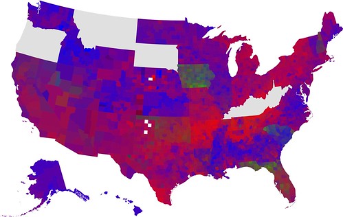
In the first place, it's easy, upon seeing a map of the United States, to imagine the outlines of the state boundaries superimposed on the map. Furthermore, the fact that you have a map of the US with the outlines of counties superimposed, along with the fact that no county crosses state boundaries, and it becomes extremely easy to guess at the state boundaries, especially when there are contrasting colors. On the colored map, then, it is fairly simple to see where the boundary lies between Kansas (which Obama won by a large margin) and Oklahoma (which Clinton won by a large margin), but the boundary between Kansas and Missouri is not so easy to distinguish. Likewise, the southern boundaries of Michigan and New York are completely indistinct, as is the entire state of Nevada. Anyone who "sees" those boundaries is merely imposing one's preconceptions of what a map should look like, in the same way that one's brain attempts to create order in a disordered image.
Maybe you're right... those are fair points all.
It's certainly true that it seems to hold only very selectively - i.e., not at all for Nevada as you mention, or for any other number of states.
For some states, however, the state borders very clearly contrast high support for, say, Obama, on one side of the state border with much lower support on the other. You mention Kansas, for example: it's not just Oklahoma with which it contrasts, there's a similar sharp line dividing the counties on the Kansas side of the state border with those on the Colorado side, as well as on the Missouri side. And that's in spite of the fact that Obama won big in Colorado as well.
Same with Illinois - with the exception of Gary, Indiana, every single county on the Indiana side of the border is distinctly darker than their neighbouring counties across the state border.
But yes, true - most states do not actually outline themselves like that. The whole Southwest, for example, is one entirely amorphous continuum, as are the states of NY, PA, OH and IN. And Illinois is, after all, maybe just a special case, as Obama's home state. Kansas, however, Tico strenuously insisted, is not in any way a 'home' state for Obama. ;-)