To finish our virtual visit to Peru, let's comment about other features of this fascinating nation.
The Nazca lines, along the Peruvian center-south shores, between Lima and Arequipa.
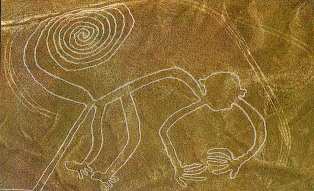
Beyond Sci-fi nut theories, they had most likely some religious meaning. Says Skepdic.com: "If Nazca was an alien airfield, it must have been a very confusing airfield, consisting as it does of giant lizards, spiders, monkeys, llamas, dogs, hummingbirds, etc."
Lake Titicaca is set beyond Macchu Pacchu, between Peru and Bolivia. It is the highest navigable lake in the world (3800 meters, some 12500 feet, above sea level).

In the top of the Puna (the Peruvian high plane), surrounded by mountains, it's full of legends: they thought it was bottomless, or that its profoundities hid cities made of gold and silver. Now it's famous for it's "hay islands"

Huancavélica is also interesting. It is a mainly Quechua and Aymara region in the Central- Southern Andes of Peru, between Lima and Ayacucho, next to the Puna heights.


The Peruvian Northeast is totally different than the rest. It's the Amazonia province. It's hot and humid capital, Iquitos, is surrounded by towns in which people live houses built over "pilotes" (I don't know the English word for those big sticks). In the Peruvian side, the Amazones is so wide, you can't see the other shore. They call it "the river-sea".
Two of the best novels by Peru's Mario Vargas Llosa, "The Green House" and "Pantaleon and the Visitors" are set in this region.