Okay, let's have a look at the so-called
Cathar Castles

Castle: medieval European stronghold, generally the residence of the king or lord of the territory in which it stands. The word is sometimes applied to prehistoric earthworks, such as Maiden Castle, England; and the word is also applied, in various linguistic forms (e.g., château, castello, or Burg), to princely mansions or country seats.
The castle developed rapidly in western Europe from the 9th century. Fortifications built in France in the 10th century often included a high mound encircled by a ditch and surmounted by the leader's particular stronghold, as in the castles at Blois and Saumur. Later, one or more baileys or wards (grounds between encircling walls), were enclosed at the foot of the mound. During the 11th century this type of private fortress, known as the "motte [mound] and bailey" castle, spread over western Europe.
The thickness of castle walls varied according to the natural strength of the sites they occupied, often varying greatly at different points of the site. The defense of the enceinte, or outer wall, of the castle was generally by means of one or more lines of moats, the moats being crossed in front of the gateways by drawbridges?-i.e., bridges that could be drawn back or raised from the inner side in order to prevent the moats from being crossed. The gateway was often protected by a barbican, a walled outwork in front of the gate; and the passage through the gateway was defended by portcullises, doors, and machicolations. Portcullises were generally made of oak, plated and shod with iron, and were moved up and down in stone grooves, clearing or blocking the passage. Machicolations were of two kinds, some being openings in the roof of the passage through which missiles were thrown on enemies forcing their way through, and others extending between the corbels of the parapets of walls and gates through which lethal missiles could be shot or dropped on the enemy below.
The baileys at the foot of the mound were enclosed by palisades and later by walls and towers of masonry. Almost at the same time that the shell keep was being erected in western Europe, the rectangular keep, a more compact form of citadel, was also being built. Examples are the donjon at Loches, Fr. (c. 1020), and the keep at Rochester, Eng. (c. 1130).
The keep, or donjon, was the focal point of the castle, to which, in time of siege, the whole garrison retired when the outer works had fallen; it was therefore the strongest and most carefully fortified part of the defenses. It had a well; contained the private apartments, offices, and service rooms; and held all the appointments necessary to sustain a long siege. Often the keep stood in line with the outer line of defenses, so that while one side looked toward the bailey (or succession of baileys) commanding the operations of the defense there, the other side commanded the field and the approaches to the castle. The side of the keep exposed to the field also presented a line of escape.
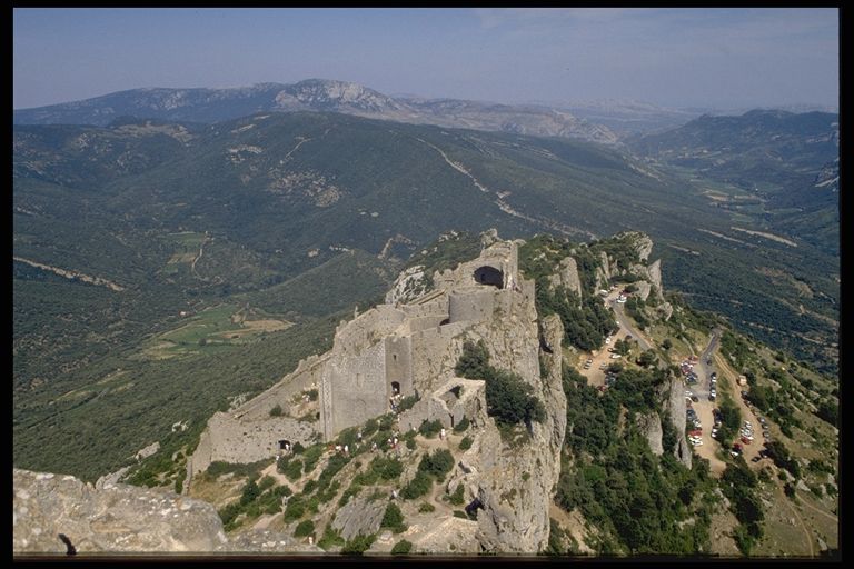
After the Third Crusade (1189-92), the site chosen for a new castle, where such choice was possible, was the summit of a precipitous hill, the citadel being backed against the cliff. The main defense was concentrated in the direction of approach, and here there were often two or three lines of advance fortifications. The living quarters?-with the hall, domestic offices, and chapel?-were then all built in the court of the inner bailey. The keep (often no longer the residence but the last line of defense) was smaller than those built previously but of more powerful design.
Development in the use of firearms was so rapid during the 15th and 16th centuries as to require a radical change in military architecture. French troops marched through Italy in 1494 and, with their guns, reduced castle after castle with astonishing rapidity. The age of the medieval castle came to an end and the era of modern military fortification opened. The principle governing the design of the new forts constructed all over Europe was that the whole building should be concentrated in one compact block. Its low walls could be defended all around by artillery, the guns being mounted on bastions and redans.
Although the break with the past did not occur suddenly, but extended over many years, there came to be from the time of the Renaissance a complete separation between military and domestic architecture; the former being a fort under military control of the monarch, the latter an unfortified palace, mansion, manor house (q.v.), or hôtel.