fbaezer
 
  2  
Reply Sat 2 Mar, 2013 03:10 pm
The other extremely poor county is Chimalhuacán.

It has a nice church

http://upload.wikimedia.org/wikipedia/commons/a/af/Iglesia_de_Santo_Domingo_de_Guzm%C3%A1n.jpg

a colourful carnival

http://upload.wikimedia.org/wikipedia/commons/6/64/Carnaval_Chimalhuac%C3%A1n.jpg

and doesn't look that bad from above the lake:

http://www.kalach.com/proyectos/chimalhuacan/chimalhuacan03.jpg

But it's damned poor...

http://www.portalexpresion.com.mx/foto/noticias/chimalhuacan.jpg

chaotic

http://www.eluniversal.com.mx/img/2011/01/Ciu/3chimalhuacan.jpg

next to a big unhealthy garbage dump

http://1.bp.blogspot.com/-nIw2HAv8ntc/Tsw3iZUNQtI/AAAAAAAAIXk/9I600lvkRFA/s400/BASURA.jpg
...and still growing with the poorest newcomers:

https://encrypted-tbn1.gstatic.com/images?q=tbn:ANd9GcTmFPXAJeDKO8kO0RoHo0V4X8GTN8UOv4JCskHLTj89_M2LNOGPBw
0 Replies
 
Ceili
 
  3  
Reply Sat 2 Mar, 2013 03:13 pm
@fbaezer,
While I understand the aversion to these type of housing units, it's a much better alternatives to some of dwellings I've seen in other places. I see what you mean by another floor, very ingenious.
My father's family (for several generations) used to be managers of a wool mill and the..what I believe was, the first or second tract housing village/development in the England, if not the world.
Apparently, we are not welcome back.. lol
Ceili
 
  2  
Reply Sat 2 Mar, 2013 03:18 pm
One more question... Why is there so much flooding in Mexico City and area? Is it flash floods? We get a 'storm of the century' every couple of years that floods areas of my city? Or is it geography, areas prone to flooding, that houses probably shouldn't have been built on those particular spots.. (just so you know, the same can be said for many places in this country too.)
fbaezer
 
  2  
Reply Sat 2 Mar, 2013 03:49 pm
@Ceili,
Yours is a very important question.

The original Aztec city was built from an island in the lake, and grew though chinampas (here, the wiki explanation of the chinampa method). It had several channels.
The conquistadors described it as magnificent, and similar to Venice.

If the city is over a lake, floods tend to be common.
They were so bad in the XVII Century that the city population was one fourth of what it used to be a century before.

In the late XIX Century there were still canals near downtown:
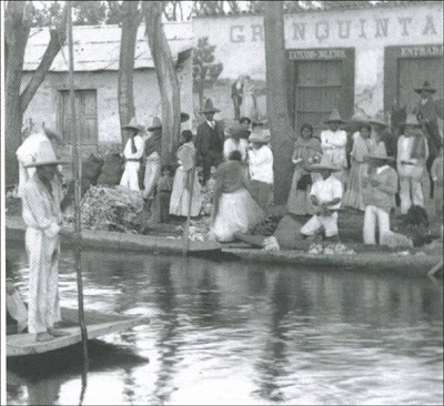
http://2.bp.blogspot.com/_LTxnQpH_g00/SXEDip0QRUI/AAAAAAAAAK8/Ex2HBqER44k/s400/4+Inundaci%C3%B3n+siglo+xix.jpg

President Porfirio Díaz ordered the lake to be dried,to prevent more flooding.
During his times, ladies paid poor indians to carry them across the often flooded streets.

Since important parts of the city were built over muddy grounds, the city sinks... and water flows to the lower areas.

As for rain, my son, who lives in the UK, noticed that statistically it rains in Mexico City as much as in Cambridge. Only in England it rains every month, in Mexico City is hardly rains between late November and early March, but Tláloc certainly makes up for it in our very very showery summer.

And water takes it course, wants to go to its original bed.
0 Replies
 
fbaezer
 
  2  
Reply Sat 2 Mar, 2013 03:53 pm
Important investments have been made to improve the sewage system -it has three levels now, in the photo, the Deep Sewage:

http://ciudadanosenred.com.mx/imagenes/imaboletin9351443.jpeg
0 Replies
 
fbaezer
 
  2  
Reply Sat 2 Mar, 2013 05:08 pm
Yearly flooding occurs in two places.
One is a neighborhood in Iztapalapa, that was constructed in a wrong place.
The other is Valle de Chalco-Solidaridad, because of the river La Compañía -which carries debris from the city.
0 Replies
 
fbaezer
 
  1  
Reply Sat 2 Mar, 2013 07:17 pm
@Ceili,
I totally agree with you on that.
ossobuco
 
  1  
Reply Sat 2 Mar, 2013 08:33 pm
@fbaezer,
Me too.

Also I'm interested in the seemingly inexorable drainage problems in some areas, with no bright ideas to offer.
0 Replies
 
fbaezer
 
  1  
Reply Mon 4 Mar, 2013 06:57 pm
Just for kicks.

The map of Mexico City's subway system:

http://www.eluniversaldf.mx/fotos/mapa_del_metro_df_lineas.jpg
0 Replies
 
fbaezer
 
  1  
Reply Mon 4 Mar, 2013 06:59 pm
You'll notice there are no subway lines in the north.

For them, the suburban train line:

http://ciudadmexico.com.mx/mapas/tren_suburbano.jpg
0 Replies
 
fbaezer
 
  2  
Reply Mon 4 Mar, 2013 07:02 pm
The Mexico City subway system is relatively new. Construction was delayed for decades due to the muddy nature of the city's underground.

The first line was inaugurated in 1969.

http://i.oem.com.mx/2e593353-f3fc-4859-ba14-48c2fccc5003.jpg

Rush hour, moving eastwards:

http://i.oem.com.mx/96033397-868a-4438-9da8-a93e83746182.jpg
0 Replies
 
fbaezer
 
  2  
Reply Mon 4 Mar, 2013 07:05 pm
Every station has a logo, according to history or toponymy:

http://bp2.blogger.com/_CtHTXwtPfjk/RoCnsc8vLvI/AAAAAAAAAEA/iXZsMRx60gE/s400/wyman_8metrostations_04.jpg

http://3.bp.blogspot.com/-RvnHWf_ptwo/UJcGzLJ0WJI/AAAAAAAAAmQ/aSiVrjNYNxI/s640/estaciones+L12.jpg
0 Replies
 
fbaezer
 
  2  
Reply Mon 4 Mar, 2013 07:07 pm
And this is the suburban train:

https://encrypted-tbn3.gstatic.com/images?q=tbn:ANd9GcSB7BIptYgZ4k9hPOUaS_R3kC8Qg2ic0IY3KGI6zxt37oqFp-f9Yw
0 Replies
 
ossobuco
 
  2  
Reply Mon 4 Mar, 2013 07:10 pm
I rode it and liked it, early seventies.. Not far, but I remember being impressed.
0 Replies
 
fbaezer
 
  1  
Reply Mon 4 Mar, 2013 07:16 pm
In order to go to Xochimilco, you need to get the "Light train".

http://upload.wikimedia.org/wikipedia/commons/thumb/9/95/Tren_ligero_mexico_DF.JPG/800px-Tren_ligero_mexico_DF.JPG

http://upload.wikimedia.org/wikipedia/commons/thumb/4/48/Tren_Ligero_de_la_Ciudad_de_M%C3%A9xico.svg/250px-Tren_Ligero_de_la_Ciudad_de_M%C3%A9xico.svg.png
0 Replies
 
fbaezer
 
  2  
Reply Mon 4 Mar, 2013 07:35 pm
Then there is the Metrobús system (Lentobús or Slowbus, we call it):

http://www.obrasweb.mx/thumb/2011/12/12/metrobus-1_659x460.jpg
0 Replies
 
fbaezer
 
  1  
Reply Mon 4 Mar, 2013 07:37 pm
RTP buses don't have an exclusive lane:

http://www.ciudadmexico.com.mx/transporte/rtp.jpg
0 Replies
 
fbaezer
 
  1  
Reply Mon 4 Mar, 2013 07:41 pm
Most common are the "peseros", who work private small bus lines and routes.
Peseros are -so far- the only ones to get into hilly zones.

http://multipolarfuture.com/wp-content/uploads/2012/10/2459899-Microbus_peseros_Mexico_City.jpg

The joke says that Santa Claus gives toys to good kids, coal to ill-behaved kids and a pesero to real son-of-bitches.
fbaezer
 
  1  
Reply Mon 4 Mar, 2013 07:47 pm
We still have our trolleys:

http://i53.tinypic.com/2hoa1rt.jpg

But trams are a thing of the past:

http://www.mexicoenfotos.com/mx/MX12910694605629.jpg
ossobuco
 
  1  
Reply Mon 4 Mar, 2013 07:49 pm
@fbaezer,
But vw's still live, don't they?
 

Related Topics

20 Years Ago: Our Earthquake - Discussion by fbaezer
Mexico City approves gay marriage - Discussion by ossobuco
 
  1. Forums
  2. » Mexico City
  3. » Page 33
Copyright © 2024 MadLab, LLC :: Terms of Service :: Privacy Policy :: Page generated in 0.03 seconds on 11/05/2024 at 04:35:49