ossobuco
 
  2  
Reply Thu 3 Jan, 2013 06:14 pm
@fbaezer,
But wait, I am not uninterested in poor neighborhoods - but I don't think you meant it that way, just that there are no biggo things to see.
Good photo. Lot of human action. Depth of field.
fbaezer
 
  1  
Reply Thu 3 Jan, 2013 06:16 pm
Besides the cute "center", Iztacalco has two of the largest neighborhoods in the city.

Colonia Agrícola Oriental (working class):

http://imganuncios.mitula.net/depto_en_agricola_pantitlan_96635342456271132.jpg

http://img.segundamano.com.mx/images/17/1731372565.jpg

Colonia Reforma Iztaccihuátl (middle class). An average house:

http://safe-img04.olx.com.mx/ui/9/84/21/f_333758321-1328547812.jpeg
0 Replies
 
fbaezer
 
  1  
Reply Thu 3 Jan, 2013 06:17 pm
@ossobuco,
That's exactly what I meant.

If I didn't include the poor neighborhoods, it wouldn't be a fair view of the city, I think.
fbaezer
 
  1  
Reply Thu 3 Jan, 2013 06:27 pm
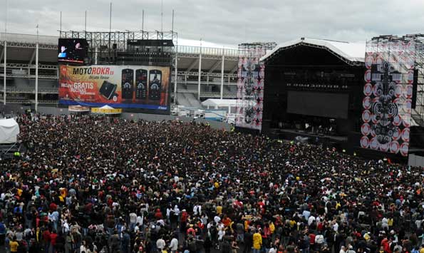
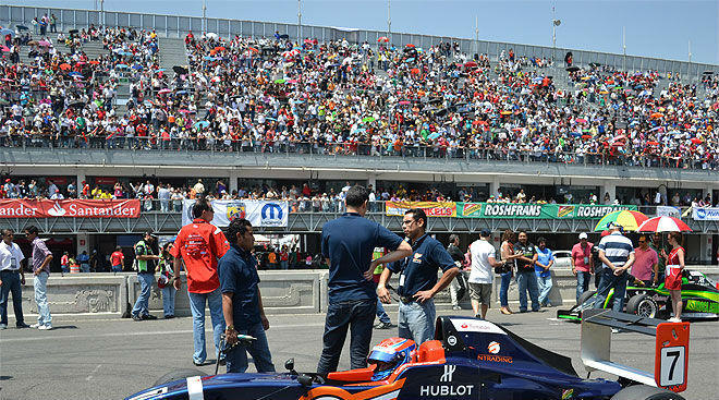
Iztacalco is also home of Foro Sol, the baseball stadium.

http://www.laaficion.com/sites/laaficion.com/files/imagecache/foto_principal/fotos/articuloexterno/19032011_LLENO_FORO_SOL_04.jpg

The Mexican League "Mexico Red Devils" play there.

I was a fan of the opposing team, the "Mexico City Tigers", and in my youth both teams played at Parque del Seguro Social.
But, stupidly, they decided to move to Foro Sol, because of lack of parking space near the old park.
I used to make 15-20 min. from my home to Parque del Seguro Social, and spend perhaps 5 min. searching for a parking place.
Foro Sol is at the east side of the city. and hundreds of thousands, if not millions live on the east and work on the center. On rush hour I make more than 1 and a half hours from my home to Foro Sol. Who cares if I can park in a jiffy?
Like me, many fans spaced their visits to the park. The Tigers moved to Cancún while still champs of the Mexican League. The hated Red Devils remained. I know how a Brooklyn Dodger fan felt.

Foro Sol is also heavily used for concerts:

http://www.mehaceruido.com/wp-content/uploads/2008/10/moto1.jpg
0 Replies
 
ossobuco
 
  2  
Reply Thu 3 Jan, 2013 06:28 pm
@fbaezer,
I agree, good grief.
Don't just skip over them as if we are all touring in loud tee shirts. I am interested-
I am interested how people survive, and not from an above point of view.
fbaezer
 
  1  
Reply Thu 3 Jan, 2013 06:36 pm
In the same sporting complex, we find the racing track: Autódromo Hermanos Rodríguez:

http://media.timeout.com/images/resizeBestFit/100541381/660/370/image.jpg

... and right next to it, the Sport Palace, Palacio de los Deportes.

http://static.tvazteca.com/imagenes/2012/46/Palacio-los-Deportes-1736721.jpg

It was originally built to host basketball games. Now it's used almost exclusively for concerts:

http://kena.com/wp-content/uploads/multimedia/Pimage_gallery.jpg
0 Replies
 
fbaezer
 
  1  
Reply Thu 3 Jan, 2013 06:41 pm
@ossobuco,
We haven't seen dirt poor yet. We'll get to that at the end, as we see the eastern outskirts of the city.
ossobuco
 
  1  
Reply Thu 3 Jan, 2013 06:44 pm
@fbaezer,
I just don't like you skipping over because there are no attractions. Attractions are not why I am paying attention - I'm interested in beginning to learn the city and thank you for it - and that happened to be a quite good photo.
fbaezer
 
  2  
Reply Thu 3 Jan, 2013 09:34 pm
@ossobuco,
I chose the photo because it told about everyday life in that neighborhood. Those aren't easy to find.

This is some kind of a travelogue, but also some kind of tour de force, believe me.

"Good" and "bad" neighborhoods will come and pass along as we move. That's why I chose the clockwise method that encircles the city center with different ratios. I could just have moved west and south and paint half of the picture.
0 Replies
 
fbaezer
 
  2  
Reply Fri 4 Jan, 2013 06:28 pm
Back to our map.

We'll visit now Delegación Benito Juárez, just south of Delegación Cuauhtémoc and Centro Histórico (light green on the map).

http://www.m-a-m.com.mx/images/Mapa-Delegaciones.png

Benito Juárez is the richest county in Mexico. According to the UN, its "Human Development Index" is similar to Germany's.
It doesn't have a very ritzy neighborhood, but it's consistently middle class.
0 Replies
 
fbaezer
 
  2  
Reply Fri 4 Jan, 2013 06:29 pm
The main corridor that crosses the area is Avenida de los Insurgentes:

http://elpositivoags.files.wordpress.com/2010/03/avenida-insurgentes.jpg
0 Replies
 
fbaezer
 
  2  
Reply Fri 4 Jan, 2013 06:43 pm
On the east of the Delegación, Colonia Narvarte, the archetipal middle class neighborhood in the city:

http://3.bp.blogspot.com/_i1Asuunt_Zg/S7P56e1UQNI/AAAAAAAAAHw/Tqbwbr02754/s1600/colonia_narvarte.jpg

Also Colonia Portales:

http://safe-img01.olx.com.mx/ui/11/01/26/1296358250_162009526_1-Amplio-departamento-en-la-colonia-Portales-Portales.jpg

Next to Insurgentes, one of the largest neighborhoods in the city: Colonia Del Valle:

http://www.mexicoenfotos.com/mx/MX12891856354109.jpg

South of Del Valle, colonia San José Insurgentes:

http://mw2.google.com/mw-panoramio/photos/medium/20601808.jpg

On the other side of Insurgentes, colonia Nápoles:

http://farm8.staticflickr.com/7051/6831304374_f1a62e7951_z.jpg

West of colonia Nápoles, colonia San Pedro de los Pinos:

http://www.ciudadmexico.com.mx/images/zones/sanpedropinos/casa_rosa.jpg

South and southwest of San Pedro de los Pinos, the town of Mixcoac:

http://www.mexicodesconocido.com.mx/assets/images/barrios%20magicos/mixcoac/mixcoac-barrio-magico-df-plaza-gomez-farias-ene11.jpg
0 Replies
 
fbaezer
 
  2  
Reply Fri 4 Jan, 2013 06:55 pm
At Narvarte, the ball park has been replaced by a mall, but the old SCOP (Public Works Department) has remained. Now it host the Secretariat of Communications and Transport.

The mosaic murals are by Juan O'Gorman:

http://www.maspormas.com/sites/default/files/styles/entrevista_full/public/sct_edificio.jpg

A few months ago, my paper denounced that the murals are coming apart:

http://www.cronica.com.mx/nimagenes/1/828f58911c_IMG_.jpg
0 Replies
 
fbaezer
 
  2  
Reply Fri 4 Jan, 2013 07:00 pm
A landmark of colonia Del Valle is the Church of The Immaculate Heart, known popularly as "Our Lady of Heavy Traffic":

http://www.razon.com.mx/IMG/jpg/p28210412.jpg

Those who saw the film "Romeo + Juliet" may recognize it:

http://www.coloniadelvalle.com.mx/imagenes/templo%20colonia%20del%20valle%20.jpg
0 Replies
 
fbaezer
 
  2  
Reply Fri 4 Jan, 2013 07:04 pm
Also at Del Valle, a couple of notable skyscrapers.

Torre Mural:

http://upload.wikimedia.org/wikipedia/commons/thumb/8/89/Torre_Mural.JPG/450px-Torre_Mural.JPG

And Torre Mexicana:

http://upload.wikimedia.org/wikipedia/commons/thumb/b/b9/Mexicanatower.jpg/800px-Mexicanatower.jpg
fbaezer
 
  2  
Reply Fri 4 Jan, 2013 07:17 pm
In a corner between Del Valle and Nápoles lies the "Sunken Park" (Parque Hundido, whose official name is Parque Luis G. Urbina). A very nice place, with different routes with replicas that guide the visitor through different prehispanic cultures.

http://www.ciudadmexico.com.mx/images/zones/delvalle/parquehundido.jpg

http://karlatone.vientopm.net/wp-content/uploads/2008/10/parque-hundido.jpg

http://ciudadinfinita.files.wordpress.com/2010/08/parque-hundido.jpg

http://www.articulosweb.net/blog/wp-content/uploads/2012/02/parque-hundido-de-ciudad-de-mexico-15.jpg
0 Replies
 
ossobuco
 
  2  
Reply Fri 4 Jan, 2013 07:19 pm
@fbaezer,
I like those skyscrapers. (This is unusual, I hardly ever like two at once)
0 Replies
 
fbaezer
 
  1  
Reply Fri 4 Jan, 2013 07:25 pm
The main feature of colonia Nápoles (and perhaps of Delegación Benito Juárez) is the building of the World Trade Center Mexico:

http://franchisestore.mx/blog/wp-content/uploads/2012/02/wtc.jpg

On the roof, a giratory restaurant:

http://www.avasa.com.mx/html/images/bellini_restaurante.png
0 Replies
 
fbaezer
 
  1  
Reply Fri 4 Jan, 2013 07:29 pm
... and below the WTC, a fruit of a strange relationship between enterpreneur Manuel Suárez and Communist painter David Alfaro Siqueiros (the two men in the statue), the Polyforum Cultural Siqueiros, a cultural, political and social facility:

http://www.elchoromatutino.com/wp-content/uploads/2011/05/000073.jpg

Here, one of the exterior walls:

http://upload.wikimedia.org/wikipedia/commons/thumb/e/e2/PolyforumSiqueiros02.jpg/800px-PolyforumSiqueiros02.jpg
0 Replies
 
fbaezer
 
  2  
Reply Fri 4 Jan, 2013 07:52 pm
Inside, the largest mural in the world, The March of Mankind:

Details:

http://www.lavozdelsandinismo.com/img/info/la-marcha-de-la-humanidad-2007-04-24-3872.jpg

http://farm3.staticflickr.com/2159/2322769620_3fa9694992_z.jpg

http://www.cronica.com.mx/oimagenes11/7/c9113aeebd.jpg

http://mw2.google.com/mw-panoramio/photos/medium/55341753.jpg

http://3.bp.blogspot.com/_Pz-BJcxtGsU/Shy-w5jF2OI/AAAAAAAAAO8/Izt1sN23s-I/s400/EVEmultimediaLpolyfF0902.jpg

As a whole, it is a metaphor about the struggle of men and women towards a better society.
It is divided in 8 panels and 4 themes: The march of mankind towards a democratic bourgeoise revolution; The march of mankind towards a future revolution; Peace, culture and harmony; and Science and Technology
0 Replies


Related Topics

20 Years Ago: Our Earthquake - Discussion by fbaezer
Mexico City approves gay marriage - Discussion by ossobuco
 
  1. Forums
  2. » Mexico City
  3. » Page 18
Copyright © 2024 MadLab, LLC :: Terms of Service :: Privacy Policy :: Page generated in 0.03 seconds on 05/14/2024 at 11:42:36