3
   

Guatemala sink-hole


Reply Tue 1 Jun, 2010 07:30 am
This is freaky:
http://www.thenewsgals.com/wp-content/uploads/2010/06/Guatemala-Sink-hole-300x199.jpg
Apparently this sink-hole opened up after a strong storm.

But if one of those things opened up there, doesn't that mean that others could open up in similar ground formations? I would find it very uncomfortable living on unsolid ground. That whole area would seem to be at risk.

And why is it so symmetrical and circular? Is this an old lava tube or something? And what's down there at the bottom of the tube, is it a large underground chamber or cave complex or something?
  • Topic Stats
  • Top Replies
  • Link to this Topic
Type: Discussion • Score: 3 • Views: 12,051 • Replies: 19
No top replies

 
Butrflynet
 
  1  
Reply Tue 1 Jun, 2010 12:40 pm
@rosborne979,
http://abcnews.go.com/Technology/guatemala-city-sinkhole-happen/story?id=10796311

Quote:
"A lot of us who study sinkholes look at this and go, 'wow,' it does seem a little bit bizarre," said Randall C. Orndorff, a program coordinator with the U.S. Geological Survey.

Orndorff said that sinkholes are common in places with rocks, such as limestone and gypsum, that can be naturally dissolved by water.

In those so-called "karst" areas, caves and voids form underground as the rocks dissolve, he said. After heavy rains or extreme drought, sinkholes can suddenly form naturally as the underground spaces open up and can no longer support the land at the surface. Human activity, such as construction, can also lead to the same consequence.

Florida , Parts of Texas , Great Lakes Area Prone to Sinkholes

In the U.S., he said, Florida, parts of Texas and the area around the Great Lakes are most vulnerable to sinkholes.

But geologists familiar with Guatemala say the issue there isn't limestone.

"The area in the city is underlayed by volcanic deposits, and these volcanic deposits make very steep-bounded canyons," said William Rose, professor in the geological engineering & sciences department at the Michigan Technological University.

In February 2007, a 330-foot sinkhole opened up in Guatemala City, also after heavy rains.

"It was found that it was due to sewer arrangements of the city, which had undermined the area. I suspect it's the same thing," he said.

Orndorff also said that though more investigation is needed, it seems that old infrastructure is to blame for the recent sinkhole.

"If you think of a sewer or water line, it's a manmade cave. At some point, if they fail, all of the soil above it and to the surface goes with it," he said.

Human Activity Can Cause Sinkholes

Orndorff said that while karst areas are most prone to natural sinkholes, infrastructure problems could lead to sinkholes anywhere.

"The reason I think we're seeing more and more … is because our population has grown so much," he said. "We're building in karst areas, which are great for farming and agriculture. Now as cities develop, we're expanding into those areas."
Related
WATCH: Bad Hurricane Season Coming?

In May 2008, he said a sinkhole in Daisetta, Texas, opened up after an underground salt dome collapsed. It ended up stretching three football field lengths in diameter and plunging 150 feet into the ground.

But he said that the most catastrophic sinkholes occur in places with mature karst development, such as Papua New Guinea, Borneo and Indonesia.

Sinkholes in those areas have been known to be a mile or two across and hundreds of feet deep.

Sometimes he said fractures in the ground or slight depressions can indicate that a sinkhole might be about to occur, but often the ground can collapse suddenly without warning.


Here's a photo with a better view:

http://www.csmonitor.com/var/ezflow_site/storage/images/media/images/0601-sink/7989476-1-eng-US/0601-Sink_full_380.jpg
rosborne979
 
  1  
Reply Tue 1 Jun, 2010 01:05 pm
@Butrflynet,
That thing looks darn peculiar to me. It seems very round and surprisingly deep (I'm not sure I can see the bottom from the photo's).

Maybe it's a combination of natural forces and human construction activity, but I would be a bit concerned about the rest of the city.
0 Replies
 
rosborne979
 
  1  
Reply Tue 1 Jun, 2010 01:10 pm
@Butrflynet,
Here's the one from 2007. It looks remarkably similar. And I think they are reporting the depth to be the same, 330 ft (30 stories) down.
http://s.ngeo.com/wpf/media-live/photos/000/211/cache/guatemala-city-sinkhole-2007_21118_600x450.jpg
0 Replies
 
rosborne979
 
  1  
Reply Tue 1 Jun, 2010 01:22 pm
Ok, here's another one in a completely different location.
http://www.cya2day.com/homeinventorydisasterimages/sinkhole1.jpg

The one from 2007 in Guatemala they blamed on a sewer main break. I guess what happens is that a sewer main or a water main breaks and nobody really notices it. So years to by and the water/sewage seeps into the ground slowly eroding away a center plug of dirt. But this happens several feet below the surface so nobody notices anything. Then a big rain comes and enough of the remaining surface dirt collapses and the hole (which has been growing for years) is revealed.
farmerman
 
  1  
Reply Tue 1 Jun, 2010 02:07 pm
@rosborne979,
Most of these circular sinkholes in volcanic areas are the result of deep "lava tubes" from SHIELD volcanoes (Hawaiian style)that disintegrate throughtime and the soils that have bridged overtop, gradually begin to fail, either by drying and shrinking, or else by wetting from heavy soaking rainfalls.
I could only find three shield volcanoes in Guiatemala and I didnt find the locations. SOmeone look up the locations for these three and see whether they correspond to the sinkhole areas. Otherwise, a really deep sinkhole like these has gotta be the result of water drainage in fractures.
AMAYO
LAS VIBORAS
PECUL

Heres a link for Guatemala volcanoes

http://www.mayaparadise.com/volcanos/volguatee.htm#amayo
Butrflynet
 
  1  
Reply Tue 1 Jun, 2010 02:09 pm
@rosborne979,
You might find this site on karstgeology interesting:

http://www.showcaves.com/english/explain/Karst/index.html
0 Replies
 
farmerman
 
  1  
Reply Tue 1 Jun, 2010 02:09 pm
@rosborne979,
Florida sinkholes arent that deep, certainly not 100 meters or more. Florida sinkholes are from dissolution of really crappy limestone "coquina rock" and from phosphate deposits that have been solubilized. Most other sinkholes are limestone or selenite and/or salt deposits from "salt dome caprocks" and "gypsum beds that are fractured up.
Hawaii has had a few lava tube sinkholes
0 Replies
 
Butrflynet
 
  1  
Reply Tue 1 Jun, 2010 02:11 pm
@farmerman,
There's a volcano in Guatemala that became active about the same time as the storm and appearance of the sink hole. I'll see if I can find the article about it again and post it.

Meanwhile, here's a Wikipedia list of areas around the glope with Karst topography.

http://en.wikipedia.org/wiki/Karst_topography
Butrflynet
 
  1  
Reply Tue 1 Jun, 2010 02:13 pm
@Butrflynet,
http://news.bbc.co.uk/2/hi/world/latin_america/10186112.stm

Hundreds of Guatemalans have been forced to flee their homes, amid an eruption by one of the country's most active volcanoes.

Pacaya began spewing lava, rocks and debris on Thursday, leaving one person dead and three children missing.

At least 1,600 people have fled the eruption, some 30km (19 miles) south of the capital city.

The volcano covered parts of Guatemala City in ash, forcing the closure of the country's main international airport.

...

Experts said the volcano's activity decreased on Friday, but warned that another major eruption was possible in the coming days.

The government is advising people in the capital not to leave their homes unless there is an urgent need.

Pacaya has erupted intermittently for decades - the last major eruption was in January 2000.
rosborne979
 
  1  
Reply Tue 1 Jun, 2010 02:16 pm
@farmerman,
So you're saying that the land beneath that Guatemalan city could be riddled with open caverns. Someone should notify CarbonSystem, maybe this is the Hollow Earth he's looking for. Smile
farmerman
 
  1  
Reply Tue 1 Jun, 2010 02:16 pm
@Butrflynet,
Amayo isnt even in Guatemala so thats one down.
B'fly, Im looking for volcanoes that produce underground lava tubes that can become the sources for sinkholes. Obviously (because the area is all built up) were not sealing with a recent volcano and vocanic pipes
Butrflynet
 
  1  
Reply Tue 1 Jun, 2010 02:17 pm
http://news.gather.com/viewArticle.action?articleId=281474978271872

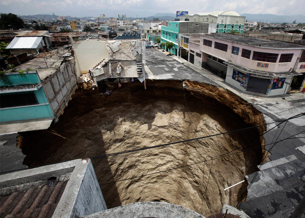
They say the sinkhole developed as a result of tropical storm Agatha, right in the middle of Guatemala City, not far from the Pacaya volcano that recently erupted. No one is saying the two events are linked, but it does seem like an unlikely coincidence.

Most sinkholes form from the movement of water under the surface. The water either dissolves soft rock (where the rock underground is made of limestone, dolomite, carbonate rock, salt beds, or other rocks that can be dissolved). Sometimes the water is natural (like the tropical storm) and sometimes it's the result of man's activities such as water-pumping and construction.Four cars drop into sink hole in Moscow's south west

In the United States, certain states are more prone to sink holes (Texas, Alabama, Missouri, Kentucky, Tennessee and Pennsylvania) but they can turn up other places, too, where one finds abandoned septic tanks, trash/garbage dumps that creates air pockets, mining activities, drilling wells close to each other and severely lowering the ground water level (exposing holes underground), or construction like building houses that adds weight to the surface.

Sink holes happen other places, too. Apparently Russia and around the Dead Sea have some rather spectacular sink holes, but even right here in Pennsylvania, we've had a number of bizarre holes. We assume it's all from mining, though, since the area is honeycombed with mines.

There is a good article at the Inspecting the World website (http://www.nachi.org/sinkholes.htm) that talks about the warning signs of sinkholes. For example, in buildings, cracks in walls, muddy well water, doors/windows that don't open properly. Other signs are objects that had previously been buried showing up (we're not talking bodies here, but things like foundations and fence posts), a circular pattern of ground cracks, sudden formation of small ponds or large puddles where none used to be, plumbing issues, slumping fences or trees, etc.

The US Government's website (http://ga.water.usgs.gov/edu/earthgwsinkholes.html) Water Science for Schools has a very interesting map of the United States that indicates prevalence of sink holes in various states.
0 Replies
 
Butrflynet
 
  1  
Reply Tue 1 Jun, 2010 02:19 pm
@farmerman,
http://vulcan.wr.usgs.gov/Volcanoes/Guatemala/Maps/map_guatemala_volcanoes.html

http://vulcan.wr.usgs.gov/Imgs/Gif/Guatemala/Maps/map_guatemala_volcanoes.gif
farmerman
 
  1  
Reply Tue 1 Jun, 2010 05:15 pm
@Butrflynet,
Those apparently dont include the extinct volcanoes of the "shield type".

HAving about 35 years in all sorts of sinkhole mitigation in mine and non-mined areas, the two BEST sources of karst geology and engineering are by Jennings ,J. N.KArst Geomorphology(1985), and Sweeting M. M.Karst Landforms (1973).
You arent in Pa are you? Yoou seem to infer that you are.
The Pa Geo Survey publishes Karst Features mapsproduced by Bill Kochanov , whose entire career has been Carbonate Karst of Pa and a bit of mine sinkhole propogation. Weve got about 65 topo maps that, in the 1990's Kochanov had tried to map every sinkhole he could find, historical and recent, as compiled from early and recent aerial photographs. He then plotted the karst features on the Pa Geo Map series maps (Map 61) and now the survey is replotting them using LIDAR tricks. Several other states have the same service, mostly for exploration teams and land developers.
farmerman
 
  1  
Reply Tue 1 Jun, 2010 05:24 pm
@rosborne979,
Only in shield volcanoes do we usually see any kind of volcanic karst, especially with that kind of expression.(Deep, clen sides drop, open throat and circular) each type of karst has its own "fingerprint" in Pa, our sinkholes usually are less circular and are more lobate. They also open as multiple sinks along a limestone fracture. We dont have any gypsum karst but we do have halogenic (salt layer) karst in the Salina and The edges of the upper Devonian section.
0 Replies
 
Butrflynet
 
  1  
Reply Tue 1 Jun, 2010 06:01 pm
@farmerman,
Quote:
You arent in Pa are you? Yoou seem to infer that you are.


Nope, that wasn't my voice, that was an excerpt from the article at the link. Should have used the quote codes for it to make it more clear.

I can see how you would have thought that though.

The voice of the author of the article:

Quote:
Apparently Russia and around the Dead Sea have some rather spectacular sink holes, but even right here in Pennsylvania, we've had a number of bizarre holes. We assume it's all from mining, though, since the area is honeycombed with mines.


My voice:

We had several sink holes in the San Francisco Bay Area in my lifetime. I've always thought it was due to the pumping of oil and gas since they mostly occur near areas where there are oil pumps. Coincidentally (?), they are also areas where there is a lot of frequent earthquake activity.
farmerman
 
  1  
Reply Tue 1 Jun, 2010 07:44 pm
@Butrflynet,
Sinkholes are direct slumps caused by cavernous voids forming under the ground and the overburden just plops into the hole created. There are several means , including pumpage of salt or oil that can cause slumps that come to the surface. These we dont usually call sinkholes. because, when we fix what caused the slump, it usually stops forever. A sinkhole is an incipient feature always. You can repair it in one area and it will open up in anither. Pumping oil usually makes the entire landsurface to sink as the interstitial sand particles are dewatered and the sand particles relax and take up less space as they compact. Do this for several hundred (or thousand) meters and that can cause a huge slump. Look at Venice Italy. AT least there, the government has been listening to their consultants and they are beginning to set up a series of "pumpo back" brine fields so that they can prevent any further slumping and sinking of the city.
0 Replies
 
calebburke
 
  -1  
Reply Tue 1 Jun, 2010 07:47 pm
I think Chuck Norris sneezed at that exact spot.
0 Replies
 
Region Philbis
 
  1  
Reply Wed 2 Jun, 2010 01:45 pm

here's another look at it...


http://inapcache.boston.com/universal/site_graphics/blogs/bigpicture/guat_06_02/g35_23652739.jpg
0 Replies


Related Topics

New Propulsion, the "EM Drive" - Question by TomTomBinks
The Science Thread - Discussion by Wilso
Why do people deny evolution? - Question by JimmyJ
Are we alone in the universe? - Discussion by Jpsy
Fake Science Journals - Discussion by rosborne979
Controvertial "Proof" of Multiverse! - Discussion by littlek
 
  1. Forums
  2. » Guatemala sink-hole
Copyright © 2024 MadLab, LLC :: Terms of Service :: Privacy Policy :: Page generated in 0.03 seconds on 04/25/2024 at 04:22:54