This morning, folks on the Weather Channel were saying the mile-wide Tuscaloosa tornado was spewing a debris field out ahead of the tornado as far as 20 miles away.
That's a circumference that would cover much of the San Francisco Bay Area.
U.S. authorities say the number of people killed in a series of tornadoes and thunderstorms across the southern United States has risen to at least 292, making it the country's deadliest tornado outbreak in almost four decades.
Alabama Governor Robert Bentley says the tornadoes that struck his state on Wednesday killed at least 194 people, by far the highest toll of the eight southern states hit by deadly storms. Speaking Thursday, he said Alabama's final death toll may not be known for another day or two.
Read more at the link.
0 Replies
JPB
2
Reply
Fri 29 Apr, 2011 08:38 am
Wow, the GOM is 2 degrees warmer than it was at this time last year.
My wife (in hat) and I went to Campbell's farmers market yesturday to enjoy the good weather. It was in the mid-seventies, and the sun felt really good. We've been eating more oranges.
At first, we had a delay yesterday evening at O'Hare: rain and thunderstorm stopped the start for an hour.
Then, we had t wait again in Denver .... until the taxiway was cleared of snow ....
0 Replies
JPB
2
Reply
Sat 14 May, 2011 12:50 pm
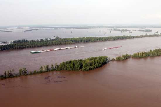
The Army Corps of Engineers is expected to begin the opening of the Morganza Spillway at approx 3:00 CDT. There will be live stream video here http://www.ustream.tv/channel/morganza
Here is the map of the estimated times for the redirected waters to reach the Atchafalaya River basin.
0 Replies
JPB
1
Reply
Sat 14 May, 2011 01:12 pm
Quote:
Opening the spillway will release a torrent that could submerge about 3,000 square miles (7,770 square kilometers) under as much as 25 feet (7.5 meters) of water in some areas but take the pressure off the downstream levees protecting New Orleans, Baton Rouge and the numerous oil refineries and chemical plants along the lower reaches of the Mississippi.
"Protecting lives is the No. 1 priority," Army Corps of Engineers Maj. Gen. Michael Walsh said at a news conference aboard a vessel on the river at Vicksburg. A few hours later, the corps made the decision to open the key spillway.
Engineers feared that weeks of pressure on the levees could cause them to fail, swamping New Orleans under as much as 20 feet (six meters) of water in a disaster that would have been much worse than Hurricane Katrina in 2005.
Instead, the water will flow 20 miles (30 kilometers) south into the Atchafalaya Basin. From there it will roll on to Morgan City, an oil-and-seafood hub and a community of 12,000, and eventually into the Gulf of Mexico, flooding swamps and croplands. Source
0 Replies
JPB
1
Reply
Sat 14 May, 2011 02:32 pm
First gate opened. Two or three more tomorrow.
What they hope will happen.
edit: the scale/grid got chopped off.
Purple= 0-5'
Blue = 5-10'
Green = 10-15'
Yellow = 15-20'
Orange = 20-25'
Red = 25-30'
0 Replies
ehBeth
1
Reply
Mon 23 May, 2011 03:10 pm
Anyone heard from our Missouri and Oklahoma posters?