Reply
Fri 4 Feb, 2005 03:04 pm
Other countries with 'and' in their name have definite parts- Trinidad AND Tobago, Serbia AND Montenegro, United Kingdom AND Northern Ireland...but I have never seen a map that separates Bosnia AND Hercegovina. Is there a distinct area 'Hercegovina' that is separate from Bosnia? Can anyone direct me to a map showing the division?
The name has to do with to separate states till the Ottomans occupied it in the 15th century.
Even the division is not clear in this link, at least you can see the two parts of the country.
Bosnia and Herzegovina
I think that the problem might be that the boundary between the two regions is not well-defined currently.
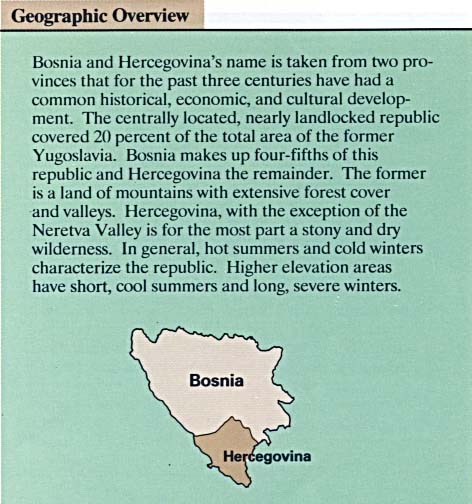
Wikipedia wrote:The country's name comes from the two regions Bosnia and Herzegovina, which have a very vaguely defined border between them. Bosnia occupies roughly the northern two thirds of the country, while the southern third is Herzegovina.
The major cities are the capital Sarajevo, Banja Luka in the northwest region known as Bosanska Krajina, Tuzla in the northeast and Mostar, the capital of Herzegovina.
Wikipedia's Bosnia & Hercegovina Page
You can find, however, at the same link fairly precise boundaries for the ten cantons that make up the Federation of Bosnia-Hercegovina as well as the seven regions of Republika Srpska.
The Library at U Texas has a map illustrating the boundaries between the two entities, however:
U Texas Bosnia-Hercegovina Map
They don't mesh with the cantons, course.
well, technically it's a hyphen, i think. Bosnia-Herzegovina. and technically, i'm not littlek, but dagmaraka, visiting littlek.
there was Czech and Slovak Federative Republic, but that one's done. Velvet Divorce it was. ummm, gotta go socialize...
Thanks. Now I are edyucated. Bayinghound's U of Texas map helped greatly.