0
   

Global air pollution map produced by Envisat's SCIAMACHY


Reply Wed 13 Oct, 2004 02:14 pm
http://www.esa.int/images/pollution_global_L.jpg


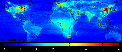
Based on 18 months of Envisat observations, this high-resolution global atmospheric map of nitrogen dioxide pollution makes clear just how human activities impact air quality.

ESA's ten-instrument Envisat, the world's largest satellite for environmental monitoring, was launched in February 2002. Its onboard Scanning Imaging Absorption Spectrometer for Atmospheric Chartography (SCIAMACHY) instrument records the spectrum of sunlight shining through the atmosphere. These results are then finely sifted to find spectral absorption 'fingerprints' of trace gases in the air.

LINK to full article and website with related links
  • Topic Stats
  • Top Replies
  • Link to this Topic
Type: Discussion • Score: 0 • Views: 803 • Replies: 1
No top replies

 
Noddy24
 
  1  
Reply Sun 24 Oct, 2004 06:14 pm
The longer the land has been settled, the greater the air pollution.

The denser the population, the greater the pollution.

Garbage Out--and it doesn't go away.
0 Replies


Related Topics

 
  1. Forums
  2. » Global air pollution map produced by Envisat's SCIAMACHY
Copyright © 2024 MadLab, LLC :: Terms of Service :: Privacy Policy :: Page generated in 0.03 seconds on 04/25/2024 at 09:24:41