Reply Mon 22 Dec, 2008 12:14 pm
How does an astrolabe work?
  • Topic Stats
  • Top Replies
  • Link to this Topic
Type: Question • Score: 4 • Views: 4,016 • Replies: 15
No top replies

 
DrewDad
 
  1  
Reply Mon 22 Dec, 2008 12:55 pm
@bobbobbob,
http://reference.howstuffworks.com/astrolabe-encyclopedia.htm

http://cse.ssl.berkeley.edu/AtHomeAstronomy/activity_08.html

http://cse.ssl.berkeley.edu/AtHomeAstronomy/images/illo_08.gif
0 Replies
 
Francis
 
  1  
Reply Mon 22 Dec, 2008 12:59 pm
The answer is on the internet:

Quote:
The astrolabe was used by the ancients ( III siecle B.C. in Greece)
for observing the relative positions and altitudes of celestial bodies.
In the Middle Age it become a navigational instrument by the addition
of tables of the Sun´s declination ( angular distance north or south of
the celestial equator), which permitted the sea navigants to find their
latitude.
In its earlier form it consisted of a disk of wood suspended by a ring.
Around the disk edge were marked the degrees of the circle; a pointer
along which the sun or another star could be sighted was pivoted on a
centre pin.
Later on the astrolabes were often made of metal with a plate with the
map of the stars and the zodiac circle on the reverse side. It was then
possible determine the time of the day: after measuring the sun´s altitude,
its position was noted on the circle of the zodiac, a line drawn to a circle
of hours showed the time.
Fountofwisdom
 
  1  
Reply Mon 22 Dec, 2008 03:04 pm
@Francis,
You need to measure time accurately: From time and stars position you can work out where you are.
DrewDad
 
  2  
Reply Mon 22 Dec, 2008 03:35 pm
@Fountofwisdom,
Fountofwisdom wrote:

You need to measure time accurately: From time and stars position you can work out where you are.

That's why,

a) They mainly shot the pole star, since it remains in the same spot no matter what the time, and made determining latitude relatively easy.
b) John Harrison won the British government's 1714 Longitude Prize (in 1761) for his marine chronometer.
Setanta
 
  1  
Reply Mon 22 Dec, 2008 03:55 pm
An astrolabe, and other, similar (and some very primitive) devices work without reference to accurate time keeping. With an astrolabe (or the notched stick used by Norse navigators), the purpose is to determine and maintain latitude. There is no portion of the world's oceans in which the changing of the season would alter the altitude of a heavenly body, especially of the sun (most commonly used for astrolabe sightings), sufficiently to cause gross error in finding latitude.

The use of reliable chronometers is crucial to finding longitude--i.e., how far east or west of a particular set point the observer will be. Latitude is a matter of determining how far north or south of the equator one is.

Norse navigators used a notched stick which the observer would hold at arm's length with the lowest notch corresponding to the horizon, and taking note of the notch at which the observed heavenly body appeared. This method was quite reliable for finding north and south on voyages which could last for weeks or even months.

Bjarni Herjolfsson was an Icelandic merchant whose father, Herjolf Bardsson, another merchant, accompanied Erik Raudi (Eric the Red) to Greenland in 985 (some sources say 986). When Bjarni returned to Iceland, he found a message from his father explaining that he (the father) had gone to Greenland, and giving the latitude in terms of the notched stick used by Norse navigators for the landfall he would have to make to reach their settlement. When the new settlers landed in Greenland, Herjolf chose the fjord leading north-northeast from that point of land for his personal settlement, so that he would be at the first landfall which merchants made when they came to Greenland, and it was known ever after as Herjolfness.

Bjarni left Iceland on the course commonly used by Icelanders sailing to Greenland (it was already known and was used as a hunting ground, even though Erik's settlement was the first). However, he was hit by a storm when out of sight of land, and was driven far off course to the southwest. When the weather cleared sufficiently for them to make sightings, and to trim their sail and ply their oars to direct their course, Bjarni quickly established that they were far to the south of the position they wanted. He therefore set his course to the north by north-northwest. He made his first landfall on what is now Newfoundland, and continued to coast to the north by north-northwest. In that manner he came to what is now Labrador. He named southern Labrador Markland because of the extensive forests (mark meaning, roughly, forest) and he named the northern coast of Labrador Helluland (hellur meaning rock or stone--the northern peninsula of Labrador is a stony, mountainous terrain).

When he had arrived at a position sufficiently north to match his sailing instructions, judging by the notched stick which he used, he turned to the east (easily determined using the sun, the moon or the stars), and sailed due east until he made landfall at Herjolfness, within a few hundred yards of the entrance to the fjord where his father had made his homestead. Despite many claims by others, Bjarni Herjolfsson is the first European of whom we have a record of someone who had made landfall on the continent of North America. His only navigational aid other than direct observation of celestial objects was a notched stick, and its purpose was identical to that of an astrolabe.
0 Replies
 
Setanta
 
  1  
Reply Mon 22 Dec, 2008 04:08 pm
The account of Bjarni's voyage can be found in the , the "Greenlander's Story." Although he reported his voyage both in Greenland, and in Iceland when he sailed there on trading voyages, he was largely ignored. However, about 10 years later (dates are uncertain in those times) Leif Eriksson bought Bjarni's ship, and using Bjarni's instructions, he sailed (apparently directly) to the southern island Bjarni had described, what we know call Newfoundland, and which Leif called "Vinland." The romantic tales of grape vines may well be chimerical--the Norse also referred to the low, creeper plants on which berries commonly grow as vines, so we don't know for certain if Leif was referring to grape vines, or berry "vines," which we would call berry bushes. Of one thing we can be certain, however, and that is that Bjarni's instructions for the latitude as determined by the use of the notched stick was sufficiently accurate for Leif to make landfall on Newfoundland after sailing directly, and out of sight of land, to the south by south-southwest.
0 Replies
 
Fountofwisdom
 
  1  
Reply Mon 22 Dec, 2008 04:14 pm
@DrewDad,
Try shooting for the North or pole star in the Southern hemisphere.
0 Replies
 
Setanta
 
  0  
Reply Mon 22 Dec, 2008 04:25 pm
Whereas your objection is correct, FoW, try telling us who, in the southern hemisphere, ever devised and used an astrolabe. DD's comment was appropriate.
0 Replies
 
Fountofwisdom
 
  1  
Reply Wed 31 Dec, 2008 04:26 am
Certainly: the British, when they sailed to Australia. Magellan and Sir francis Drake circumnavigated the globe in the 16th Century. Just admit your wrong.
DrewDad
 
  1  
Reply Wed 31 Dec, 2008 08:36 am
@Fountofwisdom,
And... did they use an astrolabe?
0 Replies
 
Setanta
 
  1  
Reply Wed 31 Dec, 2008 08:45 am
@Fountofwisdom,
The First Fleet which took the convicts out to Botany Bay sailed in 1787 and arrived in 1788. Botany Bay was "discovered" and named by James Cook in 1770. The English were using sextants in the 18th century, and not astrolabes. Neither Magellan nor Drake would have used an astrolabe because they had no charts and no information about what latitudes they needed to sail in--navigational information was a matter of state secrets in the 15th and 16th centuries, and Magellan was the first man to sail into those waters. An astrolabe would have been useless to him, since it would have told him nothing he needed to know.

At any event, DD was pointing out that people used the pole star as a reference point, and he was referring to people who sailed in the northern hemisphere. All the use of astrolabes was made by people in the northern hemisphere. You haven't responded to my question at all. Who in the southern hemisphere (not someone from the northern hemisphere sailing to the southern hemisphere) ever invented and used an astrolabe?

As DD has also pointed out, marine chronometers were available for navigational purposes after 1760. None of the competent maritime nations were using astrolabes after that. It required the accuracy of a sextant to make good use of marine chronometers, and an astrolabe would simply not have answered.

Your screen name is a satire on your "contributions" at this site.
DrewDad
 
  1  
Reply Wed 31 Dec, 2008 08:49 am
@Setanta,
Setanta wrote:

The First Fleet which took the convicts out to Botany Bay sailed in 1787 and arrived in 1788. Botany Bay was "discovered" and named by James Cook in 1770. The English were using sextants in the 18th century, and not astrolabes. Neither Magellan nor Drake would have used an astrolabe because they had no charts and no information about what latitudes they needed to sail in--navigational information was a matter of state secrets in the 15th and 16th centuries, and Magellan was the first man to sail into those waters. An astrolabe would have been useless to him, since it would have told him nothing he needed to know.

Spoilsport. I was trying to make him do his own work.
Fountofwisdom
 
  1  
Reply Wed 31 Dec, 2008 12:47 pm
And between the two dates no voyages of discovery took place? Your complete lack of knowledge of history leads to the inference that you must be American. History did not start in 1777.
The Royal Maritime Museum in Greenwich (thats a London borough) has a splendid collection of Astrolabes.
Basically because I am scientifically trained I liked to give true, if general and therefore vague answers.
As non academics you are altho intelligent, imprecise.
Slave traders would have had to cross the equator, so Americans may have used astrolabes too.
Setanta
 
  1  
Reply Wed 31 Dec, 2008 12:58 pm
@DrewDad,
Sorry about that, Boss.
0 Replies
 
Setanta
 
  1  
Reply Wed 31 Dec, 2008 01:16 pm
@Fountofwisdom,
Quote:
Your complete lack of knowledge of history . . .


This is uproariously hilarious, coming from you. Yes, i'm an American, and in this and oh so many other threads, you have demonstrated that regardless of what your nationality may be, you don't know **** about history. Tell me again about your claim that most cultures have a flood myth. Tell me again about the contributions of Henry I to Oxford University, and it's "state function." It wouldn't be hard to search your posts and come up with a dozen other boners . . . more than a dozen.

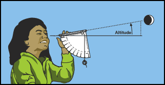
At no time did i mention the date 1777. You mentioned the English going to Australia, and i pointed out that the penal colony was started in 1788, at Botany Bay, which was mapped by Cook in 1770. In fact, the first time i mentioned a date in this thread was 985 or 986 in referring to the voyage of Bjarni Herjolfsson. Telling me how many astrolabes are at the Maritime Museum at Greenwich has absolutely no bearing on the question of who, in the southern hemisphere, ever devised and employed an astrolabe.

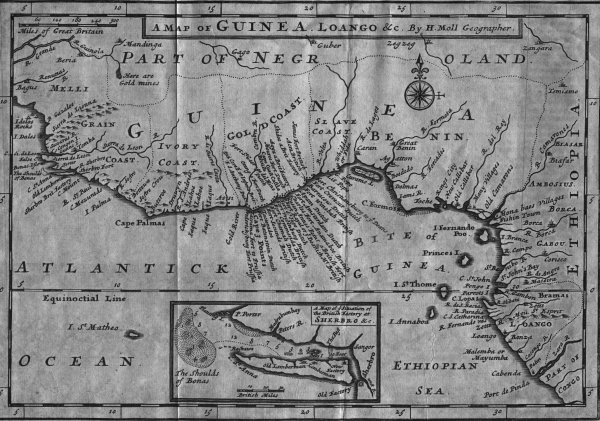
The west coast of Africa, to the north of the equator, was the venue for slave traders from Europe and North America, and as i have already pointed out, by the mid-18th century, which was when American merchants from New England began trading directly with the slave coast, mariners were using the sextant, and not the astrolabe.

Here is a map of the Guinea or Slave Coast (read the map itself), from 1731. If your "scientific training" stands you in good stead, you'll be able to see that the slave coast was all to the north of the equator--that it lay between the Tropic of Cancer and the Equator.

http://www.thegospelarmy.com/images/slave%20coast%20map.jpg

It is also hilarious to see you accuse me of giving imprecise answers. When it comes to history, i can nail your scientific ass to the wall with precision, every time.

As an academic, you are apparently incapable of correctly spelling the word "although."
0 Replies


Related Topics

Finding Copper In Terms of Cable. - Question by 6226Steff
The Book Of Life - Discussion by RexRed
Optimal Constraints - Question by koitaki
Geometry - Question by anirbanmra
please, help me with this Q - Question by darkxxx7
simple relativity question - Question by ralphiep
 
  1. Forums
  2. » Science & Math
Copyright © 2024 MadLab, LLC :: Terms of Service :: Privacy Policy :: Page generated in 0.03 seconds on 04/18/2024 at 11:42:40