Reply
Mon 29 May, 2006 07:07 pm
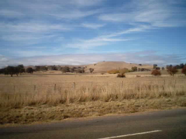
Weve been out on our friends boat this weekend and (besides getting a fierce sunburn) Ive discovered that the GPS network has been out of service. Weve only been able to acquire 3 satellites and the resulting accuracey of waypoint trekking has kept us from doing a planned waterway journey through the Lower Chesapeake back waters. So weve been doinf little short hops and relaying to other boaters whove also been a bit pissed at the lack of accuracy and +/- error bars that could mean doing a "mudbottom" crawl. Their boat draws about 6 feet unloaded (NAW) and its almost a requirement that, crawling in some slick backwaters at lowtide means that everyone stays on their asses and no rocking the boat. So, Instead of plying the estuary, I sit in this really neat hesapeake bay house that overlooks the C&D Canal.(Somebody must keep an eye on the canal)
Anybody else suffer from a lack a tech this weekend?
Odd - I didn't notice anything outta the ordinary, but I wasn't really paying that much attention to the one in my truck - it was on, and seemed nominal, but I wasn't using it - it just comes on when the ignition is switched on ... if i ain't using it, about the only time I notice it is when its doing something I don't expect. I was in and outta the truck several times during the day, noticed nothing wierd; it'd power up, initialize, get a lock, and switch to its scrolling map screen. Your report got me curious, though, so I grabbed a handheld and stepped outside with it. Nothing strange at all; initialized just fine got a good lock, and was at around 3 meter accuracy within a couple minutes, indicating my back porch is right where its s'posedta be.
So glad your back porch didn't move

DAMN, I wonder whether they werent chnging **** around. Its been going blooey all weekend. Im gonna take a walk out to the dock to take a dip (long story) and Ill check the unit and see how many satellites we get. (We need at least 5 to get accuracy enough for naving in some of these creeks. 6 satellites gives us +/_ about 3 meters which is about what Id feel comfy with in a channel thats only 50 ft wide and a boat with an 18ft beam.
Well were going out again tomorrow since all the DC birds and Philly Birds are leaving really early tomorrow to squeeze an extra day out there.
The sailboats must really be hurting because all the channel markers have been changed this year and last years charts are kaput. Now with a GPS problem I imagine those guys were all huddled up in the ship channels
Huh! I just took a quick glance through some aviation boards and newsgroups - nothing mentioned. Some twit in Michigan taxied a Piper Warrior through a closed hangar door yesterday, according to one comment, but GPS wasn't involved - just brainfade


On the subject og GPS units I have been considering buying one. Nothing too high tech. Needs to be a hand held and work under forest canopy. Needs to calculate area of an irregular polygon but not a circle. Need to download waypoints selected in a forest ( to identify areas of interest) to a mapping program and upload waypoints from points selected on a mapping program for location on the ground.
accuracy to under 10 meters would be fine.
I had the Magellan Explorer 400 in mind and thats probably about the price point but are there cheaper units that will do the same job?
http://www.nextdestination.com.au/products/brand/magellan/?category=7
Any thoughts or reccomendations?
we use Garmins and the software that allows the calculation of areas under waypoint is available from Terrain Navigator. Your need for sub meter accuracy can be compromised based upon how thick your forest canopy is.. For supreme accuracy we have a magellan surveying unit but its now over a year and a half old and new stuff is coming out every day. The exchange for higher accuracy is time in acquisition of data. Its actually quicker using an EDM for boundary surveys in open terrain. In woods and rocky terrain, EDM slows down also because of all the extra turn points needed.
LAst night when I went for a swim, I checked out the plotter and it was seemeingly back on. After 11PM I was getting 8 and 9 satellites on the registry and I was getting +/- <1 meter at about 60 secnd duration.. Were going to go out this AM and try to find the Sultana from her positions.
Thanks farmer but remember to explain for beginners like me. I am largely self taught in this subject.
EDM I assume is electronic distance measurement. I have seen one used on a small scale to measure the distance between two given points to work out an "average number of trees per hectare.
Time isnt a concern as long as its not 5 mins to get each reading. How could i tell when reviwing the literature on a particular unit if getting a reading would take an excessive amount of time? is there a recption rating or similar?
Accuracy with bounday marking is not super critical, it more a matter of me being able to get a picture of how many hectares I have pruned/thinned today/this week and for charge outs. ie instead of the current system of guessing that "that area is around 5 hectares".
With "test" plots its important for someone 10 years down the track to be able to look at the map i have made, find that particular point, remeasure trees in that area and work out annual growth since the last measuerment. Test plots are usually randomly located using a mapping program then downloaded to the unit. so that field staff can find them "on the ground.
Farmer my wireless internet connection was rotten all day yesterday.
Bummer 'bout that, 'k ... unlikely to be related though.
dadpad, i use Garmins too; others are just as good, I s'pose, but I've had Garmins for years, and i'm used to them, their mapsets, and their software, and I like 'em. Sounds to me a fairly basic unit would do all you're asking ... By what I gather from what you wrote, my E-Trex Legend handheld does all that and more. Not real sure what you mean about time to get a reading; once a GPS is on, its on and reading. The legend is shirt-pocket size, initializes and locks within a couple minutes from a cold start, and, given a clear enough view of the satellites, has <± 3-meter accuracy. Note: a heavy leaf canopy will degrade the performance of any GPS. Battery life (2 AAs) is typically 12-18 hours constant-duty, depending mostly on how much use is made of the unit's various displays and functions and the screen's backlight. It has a built-in general navigation mapset, and can be downloaded with specific special (waterways/fishing mapsets, incorporating navigation markers and bottom topography for instance), or small-area (a few square miles of high detail topo map, for instance) mapsets, or can be used via cable interface to real-time drive mapping software on a laptop or handheld - I do that a lot. Many newer units than my 1st-edition Legend now offer interchangeable flash memory modules, permitting you to load different mapsets as you please simply by plugging in an appropriately data-loaded programmable flash card. My larger, fixed-mount units have that feature, and I sometimes wish my Legend did, but its ability to drive GPS/Mapping software on a handheld or laptop sorta gets around that; I use the Legend and an iPaq loaded with the desired mapset and software when appropriate, and have found that approach satisfactory, if a bit bulky - though the combo will fit in one large pocket, or can easilly be rigged to a harness, such as a backpack would have (I've never tried a harness rig myself, but I've seen it done, and it seemed to work quite satisfactorilly for the user). I'll mention as well that there now are plug-in modules which will convert a suitable handheld into a self-contained GPS receiverl - i've seen these work just fine too, with much less bulk than the cable-connected outboard independent receiver method.
Since area calculations are a consideration for you, you're gonna want a unit that has a feature commonly referred to as 'tracking', which essentially records to memory linear progress over ground from designated point to designated point. With the legend, I set an appropriate series of waypoints, and then use the built-in 'area calculation' function to get the area enclosed within the perimeter defined by the waypoints. I've used it (along with a calculator and the pertinent formulas) for everything from calculating how much grass seed or agricultural chemical would be needed to achieve a given concentration over a given area to how many board feet of lumber or bushels of crop a given area will yield.
Anyhow, I figure you oughtta be able to readilly get your hands on an under-$200 unit that'll do all you're looking for and more. Whatever you get, be sure to read and understand its manual. Many vendors offer inexpensive instructional videos for their specific particular models, and there are many good books and articles in general publication which will help you get the most out of just about any GPS receiver.
Timber thanks for the excellent rundown.
Quote:Not real sure what you mean about time to get a reading; once a GPS is on, its on and reading.
FM mentioned (and i have heard others say this) it can take a while to register a reading under a canopy cover in a forest. perhaps i misunderstood and it is accuracy that suffers as you have indicated. I cant comment as I have never had to use one yet, but I dont expect a major problem as canopy in our young plantations is mostly thin.
I had viewed Garmin products but not extensivly.
I think the secret to success here will be the mapping program that I use with the unit.
With your information I have narrowed the choice to Etrex legend or Etrex vista (much more cost effective) (ok i know i'm a tight arse) than the magellan products.
I have sent an email to the local distributor asking for some clarification on a few points esp about compatible programs. Ie is the supplied software suitable to do what I want.
My view is I am doing most things a crop farmer would do so the progamming should be available. I just need to be able to layer in Native vegetation, buildings, possibly contour lines and a few lables.
Good stuff, thanks Mate!
There are a number of custom farming software peddlers that provide greater flexibility for you. One that Im familiar with , will take an orthophoto DVD as a base map (you can usually buy these from your most locl govt agency that deals with taxing or planning. We can buy a number of US "sections" for under 50 $ and these are all ortho corrected and in a DVD format (they are true scale photo maps wherein you can overlay your GPS lats and longs of your fields). The crop management software only needs that you provide it with data about your soil needs and drainage classes etc . With accurate locations (Thats why a GPS falls down a bit if you insist on submeter accuracy.Usually , however +/- 10 meters isnt bad for crop needs
For grading in large flat drainage areas with predetermined grades (like bases of landfills or irrigation fields) Usually EDM , crosschecked with cm level GPS will be stationed at corners of the excavation/grading. A standard desired grade (say 2%) is pre-programmed onto the EDM and its laser is sent into a spin mode. The grader blades are all outfitted with a laser reciever and this is attached to the blade hydraulics so that the grade requirement sets the blade heighth. That way the grader drivers dont have to worry about hitting all the grade stakes out in the excavation base. They can just drive throught the zone and their blades are set to take off about 6" max per pass. (Rough grubbing is done first still pretty much by stakes on the margins)
Really accurate GPS locations require really long acquisition times(up to 20 minutes per point for cm level) and often satellites are being retasked or shut off just at the days that you need them. Thats why an EDM using a laser has an accuracy and speed thats still makes it the best for big area surveys.
Are you using the GPS to control chemical applicationsand irrigation needs?
PS, everything was back to normal yesterday. We were routinely getting 8 satellites and could pretty much navigate the shallows at low tides . We actually found the ruins of an old watermans "fish town" below the Taylors Bridge area. It was a spooky location, sort f like a ghost town on stilts. Many of the locust or cypress stilts were rotting but other cabins were standing nicely. It would be neat to dive around there to see hwat artifacts remain.
Not using the gps for chemical or fertiliser apps FM.
I can see a use for this in plantation establishment. ie accurate positioning of rows could increase yields, and also establishment and possibly 2nd year weed control but once the riplines are in its pretty easy to see where you have been.
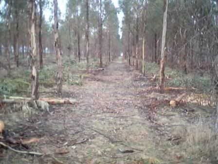
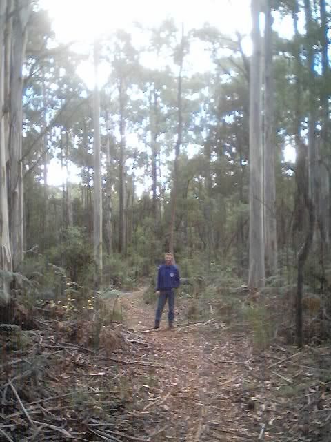
This is what we are creating
from this.......
to this........
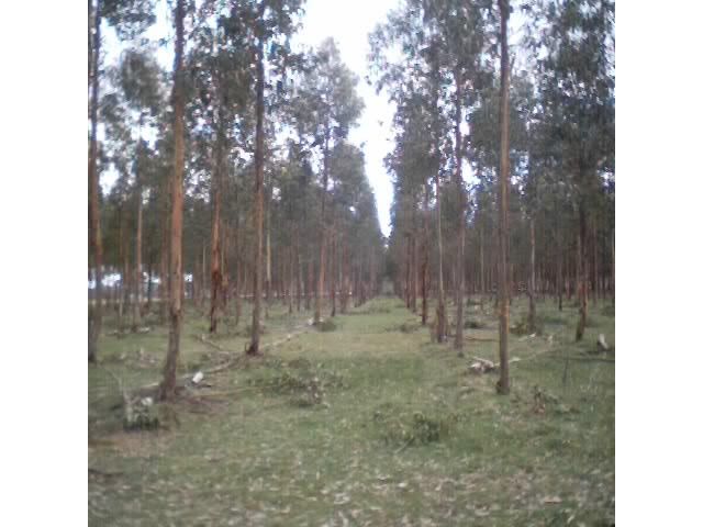
These trees are still a few years away from harvest but still looking good
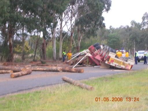
This happened out the road a bit a few weeks ago, not a truck associated with our company but still a shock to the system
Istill think that EDM would be faster and more accurate. You usually always spot your metes and bounds with an EDM and a cm GPS , and Ill bet that they both are fairly close in time spent.
AS far as making the parallel rows and drainage, EDM has many presets that allow you to mark the parallel location points and the grade and you can have a sond on a vehicle with a radio tie between the station and the receiver. The station lets you know by a series of beeps whether you are too far or too near the preset distances.
PS, what kind of trees are they? They look kinda like locust trees that we often use for fence posts.
Do you use Krovar(diuron) for understory weed control?
The truck rollover is radiata pine.
The plantations are Eucalyptus globulose (blue gum) they shed their bark annually as they grow which makes them look a little ratty.
We will produce the timber on 20 year rotations as opposed to 60-80 years for naturally grown native forest trees. We reccomend a variety of Australian natives, all with potential as timber, pulp for paper or firewood as well as value added processing wood, (kind of like chipboard but more high tech)
and cabinet timbers like blackwood and other acacias.
I will research EDM but probably dont need the accuracy at present.
In fact we use earthmoving contractors for ripline establishment so i might start looking for those guys to install that type of technology.
Weed control is Glyphosphate (roundup[size=7]tm[/size]) and Simazine for long term control. Sometimes an addition of galon or brushoff depending on what grass/woody weeds we have. Once the trees are established they dont need weed control (2 years approx) Most owners graze stock to keep the grass down.