4
   

Permian Siltstone Stratigraphy


RickJo
 
Reply Tue 21 May, 2013 10:58 pm
I need some assistance with working out what fluvial influences were at play during the formation of this Permian siltstone / mudstone strata.

To give a quick overview these layers were deposited in the Permian along the east coast of Australia. Glaciation and climate controlled sea levels influenced the patterns of sedimentation, how is what I am trying to work out.


The first picture is an overview of the cliff face with the various layers.
https://lh5.googleusercontent.com/-oAuKiGuJXM8/UZxJBv1ORlI/AAAAAAAADqQ/hD8Ml91WiK0/s640/IMG_2700.1.jpg


https://lh5.googleusercontent.com/-yoXO4GBHr7o/UZxJCNwo5jI/AAAAAAAADqU/jRJoptASlLo/s1000/IMG_2709.A.jpg
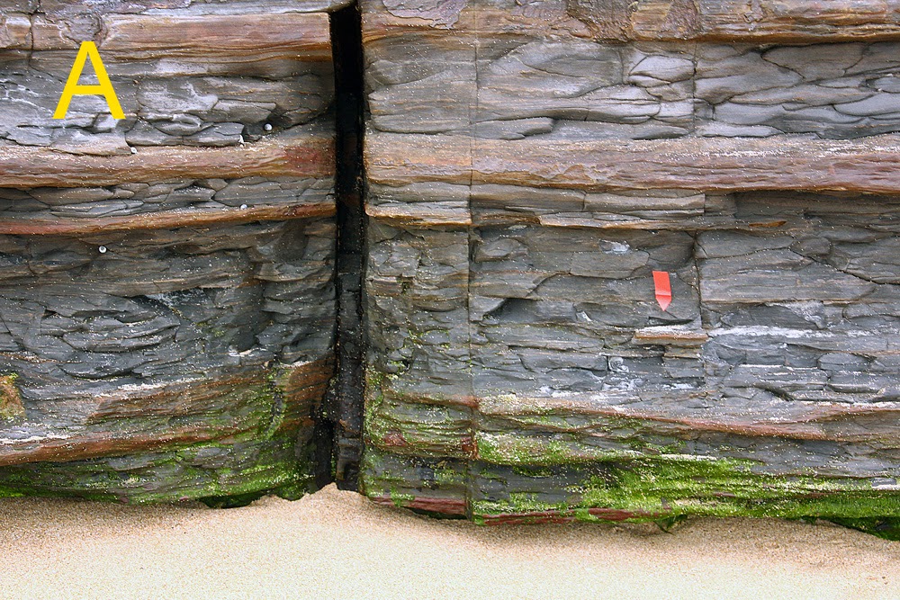
A) Due to the tell tale cracking of the layers I would say that these layers formed from mud that dried and cracked, possibly a mudflat. Can anyone offer any further observations?
(The red tag is about 2" and the lens cap is a little bigger 2.5")

https://lh6.googleusercontent.com/-vzWWxDf6iNU/UZxJIyNaWwI/AAAAAAAADqk/Eq4zctJ4W5s/s1024/IMG_2713B.jpg
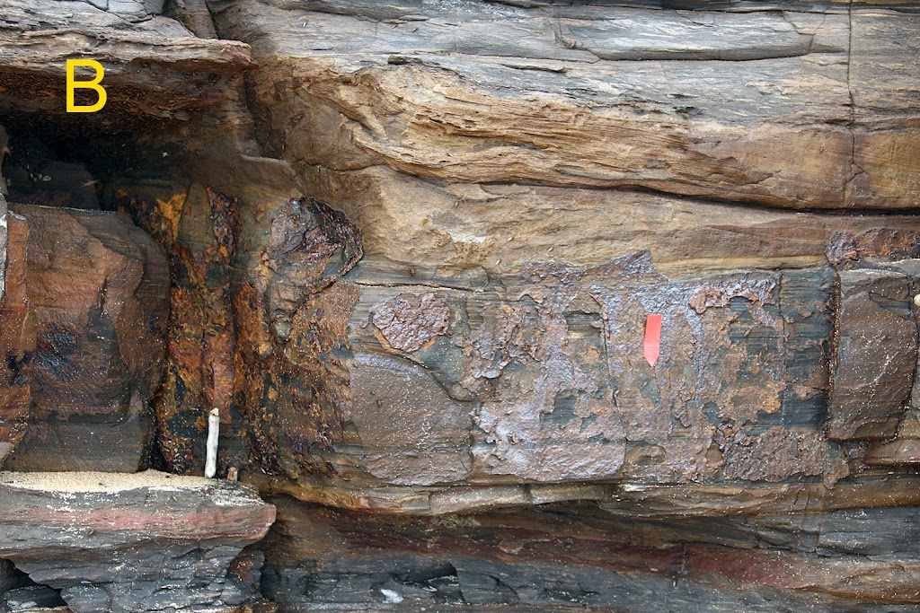
B) I do not know much about iron leaching, can anyone shed some light on why these particular layers (mostly made up of horizontal bedding) leach more then other similar bedding later in the strata?

https://lh5.googleusercontent.com/-COUDQKs5mTo/UZxJJI1Iu3I/AAAAAAAADqo/3YBJeQcjCCg/s1000/IMG_2717C.jpg
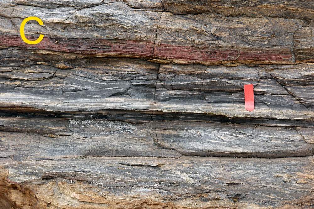
C) I am most curious to learn about what kind of flows would have caused these 'ripples' in the strata? Could the red layer have been caused by local volcanic activity?

https://lh6.googleusercontent.com/-OnogF4GpByI/UZxJL9dqMrI/AAAAAAAADq0/mxgKDYDwZY4/s1000/IMG_2731D.jpg
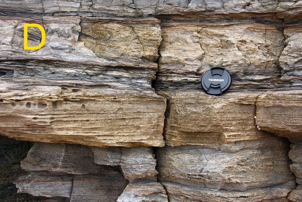
D)The horizontal bedding in this photo looks more sandy then the siltstone above and below. Would I be correct in assuming it is more sandy or is it mud that has settled when the area was frozen over?

https://lh3.googleusercontent.com/-nWYdBWL9Akc/UZxJJjc44dI/AAAAAAAADqs/HKtO7JWaUBU/s1000/IMG_2722E.jpg
E) More dried mud?

Above E is coal, this was laid down at the end of the Permian.
  • Topic Stats
  • Top Replies
  • Link to this Topic
Type: Question • Score: 4 • Views: 1,391 • Replies: 7
No top replies

 
farmerman
 
  1  
Reply Tue 21 May, 2013 11:45 pm
@RickJo,
IS this an assignment? or are you doing this as a mapping exercise?

Do you have access to making thin sections of several units?

Ill give a bit of opinion here but without a full look at the site including viewing the bedding lamiae from the surfaces , its only an opinion.
the sandier units that appear to be the reddish ones can commonly be set from a prograding discharge face, where the rock has been layed down in a suricial stream discharge point near its tidal outlet. SOrt of like cretaceous layers around the world.

Are there any fossils in the units?

Some of the units , from my view, appear to have several intersecting cross beds , have you looked at them to see imbricate structures, sole marks, or current indicators?

RickJo
 
  1  
Reply Wed 22 May, 2013 12:57 am
@farmerman,
Thanks for your reply farmerman.
Have been curious for many years, currently self learning about geology and my areas geology.
Yes there are limited fossils in the strata, most is glossopteris and worm like burrows, there is also drop stones.
I am not sure how to interpret sole marks, current indicators or imbricate structures to determine flow or tidal direction, the grains are very fine.
Can you suggest a reference source?


farmerman
 
  1  
Reply Wed 22 May, 2013 02:53 am
@RickJo,
almost any initial reference text in sedimentary petrology and strtigraphy. Sedimentary petrology will give lots of information on sole marks , (ripples, load casts etc).
The other thing that makes it difficult for long distance evaluation is the sense of the regional geology.
What are the environments of deposition that your geo survey has mapped in this area?
Always use and try to exhaust the available literature for its focus in this area.
I see several different bedding sequences in which some senses of depositional environments are indicative. .
Get a sense of what is depoitional v post depositional and then what is structural.
How far, in kilometers , do the various strata persist?
farmerman
 
  1  
Reply Wed 22 May, 2013 03:01 am
@farmerman,
BTW, the inclusions of Glossopteris is telling as to the reconstruction of the paleoenvironment. Heres a paper on the subject and , in which, there's a good table on sedimentary environmental analyses. Itll give you an idea what to concentrate on when you look into the sedimentary petrology
http://www.academia.edu/1275722/Glossopteris_-_insights_into_the_architecture_and_relationships_of_an_iconic_Permian_Gondwanan_plant
RickJo
 
  1  
Reply Thu 23 May, 2013 09:35 pm
@farmerman,
Thanks again farmerman for your comments.
The paper on Glossopteris was very interesting thank you for the link.
I have had a look in the local library at survey maps and they are not very helpful with the smaller strata, as most maps only list this whole sequences as fluvial siltstone when there is clearly more going on. I will investigate further reference text in sedimentary petrology and stratigraphy.

farmerman
 
  1  
Reply Fri 24 May, 2013 03:53 am
@RickJo,
is the "fluvial siltstone" mapped with any paleoenvironmental sense. (That's where the geologists try to reconstruct the ancient river mouths and bays , deltas, or points where the streams debauch into salt water.
A means to better understand is to look at a present embayment area and see how its located wrt any rivers or deltas etc.
Since this is undoubtedly Permian you will have to remove the structural effects of diagenesis (how the silts turned to rock) and also any effects from rifting. Your analyses should begin with the pattern of bedding and where the waters are actually going. Is the entire outcrop a classical coal sequence (a cyclothem) where there are sequences of sandstones, siltstones, clays, and coal measures


I would strt wilt a close look at the individual rock layers and get a sense of the current direction.(The glos... leaves will help a bit because they probably are arranged with some sense of direction in their masses of leaves. If not , then look for other plants and fossils to see whether some layers arent more "swamplike" Do you have or have access to a Brunton compass and do you understand how to use it?
JTT
 
  0  
Reply Sun 26 May, 2013 02:10 pm
@farmerman,
Quote:
Since this is undoubtedly Permian


I doubt very much that it is Permian, FM.
0 Replies


Related Topics

What is this..? - Discussion by jaygree
what are these marks on the rock? - Question by MaAxx8
good videos to learn geology - Discussion by danman68
MT Antero Colorado - Question by The Corpsman
Yttrium and Niobium in Granite - Question by EvilPenguinTrainer
Birth of an Ocean - Discussion by GoshisDead
Biotite vs Brown Hornblende - a noob question - Question by AllGoodNamesAreTaken
What's The Point To Geology? - Question by mark noble
Help Identifying Rocks - Discussion by mthick
identify kind of rocks - Question by georgevan1
 
  1. Forums
  2. » Permian Siltstone Stratigraphy
Copyright © 2024 MadLab, LLC :: Terms of Service :: Privacy Policy :: Page generated in 0.03 seconds on 04/26/2024 at 07:28:46