1
   

AMAZON RIVER


Reply Tue 24 Oct, 2006 01:36 pm
the BBC reports :

...AMAZON RIVER SWITCHED DIRECTION...

from the report:
Over millions of years, the Amazon has reversed its flow
The world's largest river, the Amazon, once flowed from the Atlantic Ocean to the Pacific - the opposite of its present direction, a study shows.
Sedimentary rocks in the central part of South America contain ancient mineral grains that must have come from the eastern part of the continent.

Geologist Russell Mapes says this must mean that about 145-65 million years ago, the Amazon flowed east to west.

http://newsimg.bbc.co.uk/media/images/42234000/jpg/_42234998_amazon_nasa_203.jpg
------------------------------------------------------------------------------------
since i was otherwise occupied about 100 million years ago , the reversal of the amazon was not reported earlier by me :wink: .
btw i understand that the amazon is not the only river that may have changed direction over time .
hbg
  • Topic Stats
  • Top Replies
  • Link to this Topic
Type: Discussion • Score: 1 • Views: 2,401 • Replies: 23
No top replies

 
Sturgis
 
  1  
Reply Wed 25 Oct, 2006 07:46 am
I have heard this story before; but, as of yet I don't have any solid documentation from the scientists of that time to be sure that the Amazon used to flow that way. It may just be a hoax created to divert our attentions from the approaching asteroid Shocked .


I'll have to look into this river matter a little further...
0 Replies
 
hamburger
 
  1  
Reply Wed 25 Oct, 2006 10:48 am
sturgis :
you might want to take a cruise on the amazon to visit the locals - perhaps someone remembers ?
i don't :wink: .

btw looking at the missippi river's history over just the last few hundred years shows quite dramatic changes in the flow of the river - no reversal , of course .
i would think that major volcanic eruptions may well have changed the flow of the amazon over the last 100,000 years - certainly an interesting theory .
hbg
0 Replies
 
OperaGhost
 
  1  
Reply Thu 2 Nov, 2006 09:30 pm
I don't know a lot about geology, but I don't understand how a river could change a direction of flow a little at a time. When a drop of water runs down the hand, you have to completely change the direction of the hand in order to get the water drop to run the reverse direction, which means all the water changes at the same time. I would assume that if a little of the river were to start running in a different current, that the rest of the current would either push it back into the original flow or create a whirlpool effect. Or am I way off? haha Very interesting idea though, I would love to understand more about it!
0 Replies
 
cicerone imposter
 
  1  
Reply Thu 2 Nov, 2006 09:45 pm
It seems to me I saw a place where the river flowed in opposite directions every day. It's driving me crazy to try remembering where that was, but I'm pretty sure it was in South America.
0 Replies
 
cicerone imposter
 
  1  
Reply Thu 2 Nov, 2006 09:48 pm
This is all I can find for now.

Journal of Physical Oceanography
Article: pp. 708-726 | Full Text | PDF (271K)

Estuarine Adjustment to Changes in River Flow and Tidal Mixing
Parker MacCready11. School of Oceanography, University of Washington, Seattle, Washington
ABSTRACT
The adjustment of estuarine circulation and density to changes in river flow and tidal mixing is investigated using analytical and numerical models. Tidally averaged momentum and salinity equations in a rectangular estuary are vertically averaged over two levels, resulting in equations that are analytically tractable while retaining a broad range of time-dependent behavior.

It is found that both strongly stratified and well-mixed estuaries respond rapidly to either type of forcing change, while those of intermediate stratification respond more slowly. Intermediate estuaries also have the greatest sensitivity to change.

Exchange flow dominates the up-estuary salt flux in strongly stratified cases. Changing the river flow in such cases leads to an internal wave propagating the length of the estuary, which accomplishes much of the adjustment. The internal wave speed thus controls the adjustment time. Increased tidal mixing in strongly stratified cases initially decreases the exchange flow contribution to up-estuary salt flux by decreasing both the stratification and the vertical current shear. However, the decreased up-estuary salt flux leads to a loss of total salt in the estuary, and hence a greater longitudinal salinity gradient. The increasing gradient eventually restores the exchange-flow salt flux to near its original value. Well-mixed solutions have an advective-diffusive balance between river flow and longitudinal tidal mixing. In these cases the adjustment time corresponds to the time it takes the depth-averaged flow to travel the length scale of the salt intrusion, a result that applies to both types of changes considered.

In all cases the adjustment depends upon the dynamical feedback between the longitudinal salt flux and the longitudinal salinity gradient, which varies as the estuary gains or loses total salt.

Manuscript received February 24, 1997, in final form May 8, 1998

DOI: 10.1175/1520-0485(1999)029<0708>2.0.CO;2
0 Replies
 
rosborne979
 
  1  
Reply Thu 2 Nov, 2006 10:04 pm
All rivers flow in a particular direction: Down

Since the Amazon river results from the snow melt from the Andes Mtns, then unless the floodplane was at one time higher than the Andes, then the Amazon probably always flowed 'down' from the Andes to the Atlantic.

Sometimes tidal surge from the Atlantic causes backwash into the delta, but the primary flow of the river is always the same.
0 Replies
 
rosborne979
 
  1  
Reply Thu 2 Nov, 2006 10:06 pm
All rivers flow in a particular direction: Down

Since the Amazon river results from the snow melt from the Andes Mtns, then unless the floodplane was at one time higher than the Andes, then the Amazon probably always flowed 'down' from the Andes to the Atlantic.

Sometimes tidal surge from the Atlantic causes backwash into the delta, but the primary flow of the river is always the same.
0 Replies
 
littlek
 
  1  
Reply Thu 2 Nov, 2006 10:22 pm
Or, could the mountains have been lower and the river fed by something else? Not likely. But, when were the andes upthrust? Aren't they relatively young?
0 Replies
 
rosborne979
 
  1  
Reply Fri 3 Nov, 2006 06:31 am
littlek wrote:
Or, could the mountains have been lower and the river fed by something else? Not likely. But, when were the andes upthrust? Aren't they relatively young?


Even if the Andes were young, I would expect them to be many millions of years old.

The Andes also cause the Amazon. It's the snow melt from them which feeds a large portion of the system.

So back when the Andes didn't exist, I don't thinkg the Amazon river would have existed either, unless it was just a big lowland swamp.
0 Replies
 
squinney
 
  1  
Reply Fri 3 Nov, 2006 06:53 am
Scientists are talking about changes taking place now that will eventually cause the world to "flip." The South Pole will become the North Pole.


Maybe that HAS happened before.... Do you ever remember being flipped, Mr. Burger?
0 Replies
 
farmerman
 
  1  
Reply Fri 3 Nov, 2006 07:00 am
Remember, from about 2.3 Billion years through the Cambrian, all the plate collisions were happening on the East Coasts of South America ( RHODINIA and later GONDWANA). SO its entirely possible that the sediments were being shed from a very large, very old mountain range to the Eastern parts of Brazil Depending on the primary winds , this could have been a very wet or very dry area because Africa was attached to the back end of the plate. So this mountain range was periodically revitalized and then eroded away(think Appalahians and Caledonides). The remnants of these mountains can be seen in lots of places in E S America.

The ANdes are quite young, with major mountain building through the Holocene. In fact they are still risng, so,heres a little ditty from a friends work about the age of the Andes and the fauna (Im not sure that there is a word like "endemism", it sounds more like a religion. Ill have to razz them about making up words to plop into sentences just to sound elite--)

I had another colleague who used to use FARCTATE alot
Quote:
Perhaps the best-sampled temporal interval is the early-mid Miocene (~20-11 Ma), with important Andean assemblages (complementing the classical record from lowland Argentina) now known from S. Chile (47°S) to Colombia (3°N). Intervening sequences occur throughout central Chile, the Chilean and Bolivian Altiplano, and Ecuador. This interval now appears to represent a time of pervasive orogenesis and rapid uplift throughout much of the Andes, undoubtedly with major biotic ramifications (reflecting environmental change, increased topographic complexity, and geographic isolation creating endemism).
0 Replies
 
rosborne979
 
  1  
Reply Fri 3 Nov, 2006 07:25 am
squinney wrote:
Scientists are talking about changes taking place now that will eventually cause the world to "flip." The South Pole will become the North Pole.


And when it does, the sun will rise at night and set in the morning, birds will fly upside down, and flat-earthers and creationists will finally get their long awaited 'last laugh'.
0 Replies
 
farmerman
 
  1  
Reply Fri 3 Nov, 2006 09:13 am
...dogs and cats living together....

I know , but its still a great line...
0 Replies
 
roger
 
  1  
Reply Fri 3 Nov, 2006 11:27 am
cicerone imposter wrote:
It seems to me I saw a place where the river flowed in opposite directions every day. It's driving me crazy to try remembering where that was, but I'm pretty sure it was in South America.


Sounds like the Tidewater region of our east coast, too. At low tide the rivers run into the sea; at high tide, the tides back up the rivers. If your timing is good, the tides will pump fresh water into you irrigation system for free. If your timing is off, well, cotton tolerates salt water better than wheat.
0 Replies
 
cicerone imposter
 
  1  
Reply Fri 3 Nov, 2006 11:32 am
roger, That explanation makes the most sense, and that's probably what we saw.
0 Replies
 
hamburger
 
  1  
Reply Fri 3 Nov, 2006 05:32 pm
...SAINT JOHN RIVER REVERSES FLOW ... DAILY !...

the saint john river (in the bay of fundy/new brunswick) is one of the rivers reversing its flow when the water gets pushed into the bay .
btw its called a 'tidal bore' , and there are the 'reversing falls' - quite a sight to see .
hbg

from the link :
"The bay's extreme tidal range causes several interesting phenomena in the various rivers which empty into it.

The Saint John River sees its flow reversed at high tide, causing a series of rapids at the famous Reversing Falls where the river empties into the bay, located in a gorge in the middle of the city of Saint John."
0 Replies
 
hamburger
 
  1  
Reply Fri 3 Nov, 2006 05:41 pm
come visit the 'bay of fundy' and 
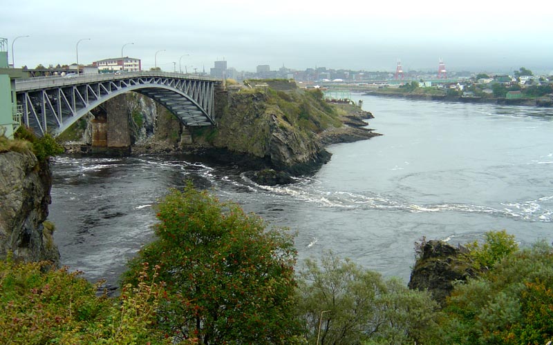
...THE REVERSING FALLS...

"The Reversing Falls is a unique phenomenon caused by the tremendous tide in the Bay of Fundy - the highest tides in the world. The bay's tidal action is affected by the funnel shape of the bay and by the moon's phases.

At low tide, the St. John River, which runs for 450 miles through the Province of New Brunswick, empties into the bay through a narrow rocky gorge. Near Fallsview Park, an underwater ledge, 36' below, causes a boiling series of rapids and whirlpools. The rising tide slows the river current to a stop and for 20 minutes a rest period called low slack tide allows boats to navigate the Falls. Once the tide is higher than the river, the reversal of the current occurs and continues until high tide. The water rises up to 14 1/2 feet above sea level in the gorge.

Then the tide slowly descends but still flows inland until it is at river level again (high slack). After 20 minutes rest, the river resumes its natural flow and the tide drops away to low tide revealing the rapids and whirlpools again.

It is recommended to view the Falls twice - near low tide and near high tide. A film presentation of the Reversing Falls can be viewed in the Rooftop Theatre at the Falls Restaurant for a small fee.

View this wonder from two vantage points - Fallsview Park and the Falls Restaurant observation deck. "

http://www.wefly4fun.com/ByCarNE04-07_files/SJtideOut-W.jpg
0 Replies
 
cicerone imposter
 
  1  
Reply Fri 3 Nov, 2006 05:45 pm
Nature never ceases to amaze.
0 Replies
 
littlek
 
  1  
Reply Fri 3 Nov, 2006 05:57 pm
Squinney - the poles 'flip' periodically. More specifically, the positive and negative charges change. As liquid rock comes up to fill the gap left as the oceanic rifts spread (as the continue to do), they register the polar magnetic charge. Then they harden and form the ocean floor. By looking at pieces of that spreading floor, scientists know that the charge has flipped - and that we are over due for another flip. What that means to us in our daily existence, I dunno.
0 Replies


Related Topics

Evolution 101 - Discussion by gungasnake
Typing Equations on a PC - Discussion by Brandon9000
The Future of Artificial Intelligence - Discussion by Brandon9000
The well known Mind vs Brain. - Discussion by crayon851
Scientists Offer Proof of 'Dark Matter' - Discussion by oralloy
Blue Saturn - Discussion by oralloy
Bald Eagle-DDT Myth Still Flying High - Discussion by gungasnake
DDT: A Weapon of Mass Survival - Discussion by gungasnake
 
  1. Forums
  2. » AMAZON RIVER
Copyright © 2024 MadLab, LLC :: Terms of Service :: Privacy Policy :: Page generated in 0.04 seconds on 04/25/2024 at 01:24:52