fbaezer
 
  2  
Reply Thu 21 Feb, 2013 06:04 pm
Now we move back north, get lost a bit in the traffic, but finally arrive to downtown Tlalpan.
Tlalpan is another town swallowed by the city. It even was the capital of the state of Mexico for a few years in the XIXth Century.

http://upload.wikimedia.org/wikipedia/commons/thumb/c/c7/Explanada-Tlalpan.jpg/404px-Explanada-Tlalpan.jpg

http://www.mexplora.com/viajes-mexico/wp-content/uploads/2012/06/Tlapan.jpg

http://ciudadanosenred.com.mx/imagenes/imaboletin8781366.jpeg

http://1.bp.blogspot.com/_FdQCpRWd7Fk/Spkxbq1LcnI/AAAAAAAAAws/qA2CM1jdXyE/s400/TLALPAN_centro.jpg

http://www.hearwego.com.mx/esp/admin/caratulas/148_intro_centro_de_tlalpan.jpg

It is similar to Coyoacán's, but without as many restaurants and boutiques.
0 Replies
 
fbaezer
 
  1  
Reply Thu 21 Feb, 2013 06:07 pm
Another feature of Tlalpan is the posh neighborhood of Tlalpuente, which boasts that it's ecological, because it has a lot of green:

http://safe-img02.olx.com.mx/ui/12/96/03/1344990716_311029303_12-CASA-EN-VENTA-CAMINO-REAL-TLALPUENTE-MEXICO-D-F-.jpg

http://img1.mlstatic.com/casa-en-renta-en-tlalpuente_MLM-O-3464297177_112012.jpg

http://imganuncios.mitula.net/terreno_tlalpuente_tlalpan_renta_3_015_000_96635349862764879.jpg
0 Replies
 
fbaezer
 
  2  
Reply Thu 21 Feb, 2013 06:13 pm
Next borough (or delegación) to visit, Magdalena Contreras, west of Tlalpan, east of Alvaro Obregón:

http://upload.wikimedia.org/wikipedia/commons/thumb/e/e6/Magdalena_Contreras%2C_M%C3%A9xico.svg/448px-Magdalena_Contreras%2C_M%C3%A9xico.svg.png
0 Replies
 
fbaezer
 
  1  
Reply Thu 21 Feb, 2013 06:15 pm
Not much to show about Magdalena Contreras.
But the giant flag in the middle of the freeway sure is impressive:

http://spf.fotolog.com/photo/31/14/9/ciudad_de_mexico/1246404720366_f.jpg
fbaezer
 
  1  
Reply Thu 21 Feb, 2013 06:18 pm
Magdalena Contreras is hilly, and has neighborhoods of all types, from fancy San Jerónimo to dirt poor Cerro del Judío:

http://safe-img03.olx.com.mx/ui/2/01/60/1354729767_453960160_1-Venta-de-Casa-en-AlcajetesSan-jeronimo-Lidice-Magdalena-Contreras-San-Jeronimo-Lidice.jpg

http://www.equilibrio.mx/images/stories/21%20OCT%20Mexico%20slum.jpg
0 Replies
 
fbaezer
 
  2  
Reply Thu 21 Feb, 2013 06:34 pm
As with the road to Ajusco, at Magdalena Contreras, the more you climb, the more different the housing becomes:

http://img001.adimg.com/ImgAd/2009/11/27/800117/renta-de-cabanas,-campismo,-ajusco-parque-ejidal-san-nicolas-totolapan_3.jpg

http://imganuncios.mitula.net/casa_san_nicolas_totolapan_la_magdalena_contreras_venta_6_000_000_96635350275991903.jpg

Here, you don't arrive at Ajusco, but at another National Park, called Los Dinamos:

http://cdn1.mx.yumping.info/emp/fotos/3/3/4/1/tgr_Ciclismo%20de%20monta%F1a.JPG

https://encrypted-tbn1.gstatic.com/images?q=tbn:ANd9GcQAUAa05OjUHp_kiVunm1QWiCFPs0TXWvypXnGLoy_hQQmPj9f9

http://upload.wikimedia.org/wikipedia/commons/thumb/2/24/Dinamos_2009.JPG/800px-Dinamos_2009.JPG

Unlike Ajusco which is snowy almost every winter, there's no winter snow at Los Dinamos.

In fact, only twice in my life has snow fallen in Mexico City proper, January 1967 and March 1988 (and then only on Tlalpan, Xochimilco and parts of Coyoacán).
0 Replies
 
fbaezer
 
  1  
Reply Thu 21 Feb, 2013 06:42 pm
The House of Culture at Magdalena Contreras:

http://upload.wikimedia.org/wikipedia/commons/thumb/2/2b/Foro_Cultural_-_Magdalena_Contreras.JPG/611px-Foro_Cultural_-_Magdalena_Contreras.JPG

A view of Luis Cabrera Avenue, the most important road in the delegación.

http://upload.wikimedia.org/wikipedia/commons/3/37/Ciudad_de_Mexico%2C_Magdalena_Contreras-Avenida_Luis_Cabrera.jpg
0 Replies
 
fbaezer
 
  2  
Reply Thu 21 Feb, 2013 06:45 pm
We finish the Federal District, with a visit to Milpa Alta, the southermost delegación:

http://upload.wikimedia.org/wikipedia/commons/thumb/3/34/Milpa_Alta_locator_map.svg/250px-Milpa_Alta_locator_map.svg.png

Milpa Alta is the least populated borough of the city (130,000 inhabitants). In fact it's mainly rural.
It is also the poorest borough.
I must confess I have never been to Milpa Alta.

0 Replies
 
fbaezer
 
  1  
Reply Thu 21 Feb, 2013 06:49 pm
Milpa Alta, a general view:


http://www.afectadosambientales.org/wp-content/uploads/milpa-alta.jpg

The village

http://www.elvicio.com.mx/cabaret/wp-content/uploads/2012/05/DSC_4655_ch.jpg

http://www.quadratinmexico.com/wp-content/themes/qmex/timthumb.php?src=http%3A%2F%2Fwww.quadratinmexico.com%2Fwp-content%2Fuploads%2F2013%2F01%2FDSC_0319.jpg&q=90&w=640&zc=1
0 Replies
 
fbaezer
 
  1  
Reply Thu 21 Feb, 2013 06:52 pm
The most famous event at Milpa Alta is the Feria del Mole, where this typical Mexican delicacy is served and sold (specially the paste to make mole at home):

https://encrypted-tbn1.gstatic.com/images?q=tbn:ANd9GcRvJAeiI25awLRbsi9Bvf5R5gQII5YYhSXzuNvqblMdiC0vh9-u

http://static.tvazteca.com/imagenes/2010/40/331982.jpg

http://4.bp.blogspot.com/_IzWXhEVBoAQ/RvkrXUpTQSI/AAAAAAAAC4o/zvAAyLixOCs/s400/mole.jpg

http://www.eluniversal.com.mx/img/2010/10/Ciu/4MOLE2.jpg
fbaezer
 
  2  
Reply Thu 21 Feb, 2013 07:04 pm
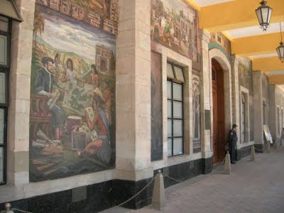
With this, we finish the virtual visit to the Federal District.
As you could see, if you followed the thread, the city ends on the south and the southwest. Not so on the west, north and east.

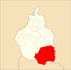
In other words, we've seen only the part of the map in green.

About 9 million people inhabit the Federal District, 10 million more live in the outskirts.

http://www.ub.edu/geocrit/sn/sn-194-101_archivos/image006.jpg

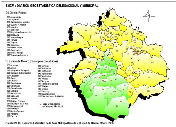
This map of Greater Mexico City will perhaps scare you, but -with some exceptions- the outskirts are not half as interesting as the rest of the city, so we'll go faster through them.

As we've done before, we'll move clockwise, starting west.
0 Replies
 
fbaezer
 
  2  
Reply Thu 21 Feb, 2013 07:13 pm
Since the hampster is bugging me with "flood prevention", I will post pictures of the outskirts another day.

Only one thing to remember. As in the Federal District, there is a clear class-cut division of the outskirts. Rich and middle-class on the west side of the city, working class and poor in the north and east.

In fact, before the big PRI victory in last year's elections, the west part of the outskirts was named "the blue corridor", for all the mayors were from the conservative party, and the east part was named "the yellow belt", for all the mayors were from the left wing party. In 2012, the blue corridor dissapeared and the yellow belt lost some of its colour.

(Mexico City proper has a left wing mayor, and all the delegaciones but two are governed by the left; the exceptions are Benito Juárez, which is still conservative and Cuajimalpa, won by the PRI).
0 Replies
 
cicerone imposter
 
  2  
Reply Thu 21 Feb, 2013 08:01 pm
@fbaezer,
I also noticed huge flags flying in Mexico City.
fbaezer
 
  1  
Reply Fri 22 Feb, 2013 12:49 pm
@cicerone imposter,
There are 3 huge flags. One at Zócalo, one at Campo Marte (next to the National Auditorium) and the megahuge one at San Jerónimo.
0 Replies
 
InfraBlue
 
  2  
Reply Fri 22 Feb, 2013 01:32 pm
@fbaezer,
fbaezer wrote:

The most famous event at Milpa Alta is the Feria del Mole, where this typical Mexican delicacy is served and sold (specially the paste to make mole at home):

https://encrypted-tbn1.gstatic.com/images?q=tbn:ANd9GcRvJAeiI25awLRbsi9Bvf5R5gQII5YYhSXzuNvqblMdiC0vh9-u

http://static.tvazteca.com/imagenes/2010/40/331982.jpg

http://4.bp.blogspot.com/_IzWXhEVBoAQ/RvkrXUpTQSI/AAAAAAAAC4o/zvAAyLixOCs/s400/mole.jpg


Hey, I was looking up moles some time ago and came across this image from San Pedro Atocpan there in Milpa Alta:
http://i1020.photobucket.com/albums/af324/infrablu/25f92694-3f8d-4e6c-afc6-382afba25afb_zps547ee35b.jpg

I wonder if any of those moles are available for export.
cicerone imposter
 
  2  
Reply Fri 22 Feb, 2013 02:17 pm
@InfraBlue,
Here's an interesting info on mole sauce on Wiki.
http://en.wikipedia.org/wiki/Mole_(sauce)
0 Replies
 
InfraBlue
 
  1  
Reply Fri 22 Feb, 2013 02:29 pm
Oh yeah, I love mole.

I'm relegated to buying the Doña Maria brand and adding Abuelita chocolate to it. HA
ossobuco
 
  1  
Reply Fri 22 Feb, 2013 02:43 pm
@InfraBlue,
Good question, InfraB.

I don't go to my nearest markets that might have the exports (if they are exported) since at the nearest they are far away for me.
0 Replies
 
ossobuco
 
  1  
Reply Fri 22 Feb, 2013 02:54 pm
@InfraBlue,
Lots of moles online - I looked them up once, many variations. Puebla, Oaxaca, and more.

Here's a quote from an LA Weekly article -

"Mole is so rich, thick, complex and flavorful that many consider it a main dish, ideal with just tortillas or rice. All moles are based on chiles and spices that have been toasted, roasted, ground, and cooked -- ingredients can range from a couple of dozen to several dozen. But many types exist, beyond the popular mole poblano (Puebla-style) and mole negro (black, Oaxacan-style) that we see most often in L.A. Even from regions other than Puebla and Oaxaca, the two most acclaimed mole-makers. Ever try almond mole from Mexico City? Pink mole from Taxco?"


Sigh.
ossobuco
 
  2  
Reply Fri 22 Feb, 2013 03:14 pm
@ossobuco,
Pardon me, fbaezer - a short and quick detour

a few mole recipes I posted on another thread -
http://able2know.org/topic/184658-1#post-4897457
 

Related Topics

20 Years Ago: Our Earthquake - Discussion by fbaezer
Mexico City approves gay marriage - Discussion by ossobuco
 
  1. Forums
  2. » Mexico City
  3. » Page 28
Copyright © 2024 MadLab, LLC :: Terms of Service :: Privacy Policy :: Page generated in 0.03 seconds on 04/23/2024 at 03:50:06