6
   

Total Solar eclipse of August 21, 2017


rosborne979
 
  2  
Reply Tue 16 Aug, 2016 12:41 pm
@rosborne979,
https://www.sciencenews.org/article/astronomers-prepare-2017-solar-eclipse-spectacle
https://www.sciencenews.org/sites/default/files/2016/08/081516_cc_solar-eclipse-path_free_rev.png
rosborne979
 
  1  
Reply Tue 16 Aug, 2016 12:43 pm
@rosborne979,
NASA Link: http://eclipse.gsfc.nasa.gov/SEgoogle/SEgoogle2001/SE2017Aug21Tgoogle.html
0 Replies
 
rosborne979
 
  1  
Reply Mon 22 Aug, 2016 01:05 pm
Wow, this getting more press than I thought it would:
http://miami.cbslocal.com/2016/08/22/1-year-countdown-begins-for-the-great-american-eclipse
0 Replies
 
oralloy
 
  1  
Reply Thu 8 Sep, 2016 12:31 am
http://static1.squarespace.com/static/53c358b6e4b01b8adb4d5870/t/57a76bc6cd0f687aa2295c57/1470589946411/USAtopten_1500px.jpg

http://www.greatamericaneclipse.com/best-places-to-view/

The link also has closeup maps for each location. These closeup maps illustrate an important issue that I think hasn't been mentioned yet. Not every location in the "path of totality" is equal. The time of totality is longest in the center of the path, with the eclipse becoming briefer as you move away from the center of the path. At the very edge of the path, the time of totality will be a single instant.

So you won't want to find just anywhere in the path of the eclipse. You will want to be in the center of the path.
0 Replies
 
oralloy
 
  1  
Reply Thu 8 Sep, 2016 01:15 am

This page has a good charting of likely cloud cover:
http://eclipsophile.com/total-solar-eclipses/total-solar-eclipse-2017-august-21/

They also have highly-detailed information on likely cloud cover for each state.

East of the Rockies, Alliance Nebraska looks pretty close to ideal.

http://eclipsophile.com/wp-content/uploads/2015/08/cloudmaps.jpg
http://eclipsophile.com/wp-content/uploads/2015/11/am-pm-satcloud2.jpg
0 Replies
 
oralloy
 
  1  
Reply Thu 8 Sep, 2016 01:26 am

Here is another page that charts likelihood of cloud cover:
http://www.eclipse2017.org/2017/weather/2017_clouds.htm

It differs a bit from the page that I previously linked. The chart has a dip west of North Platte though, right about where Alliance Nebraska would be. So Alliance still looks like a pretty good spot.
http://www.eclipse2017.org/2017/weather/cloud/2017_cloud_USA.png
http://www.eclipse2017.org/2017/weather/cloud/CentrelineCloud.png
0 Replies
 
rosborne979
 
  1  
Reply Thu 8 Sep, 2016 04:20 am
Thanks for the info. Will you be traveling to see this?
oralloy
 
  1  
Reply Thu 8 Sep, 2016 06:51 am
@rosborne979,
I certainly hope so. I don't really have any plans yet though. Or even any idea where along the path I want to aim for.

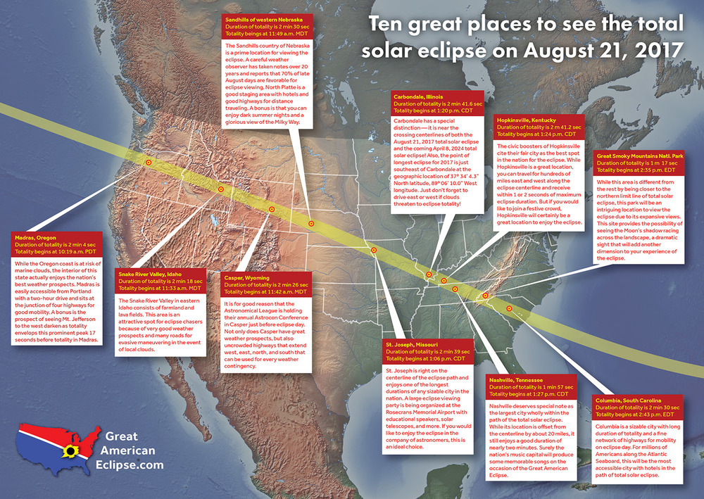
That idea of the observation tower atop Clingman’s Dome is interesting if (IF!) the weather cooperates.

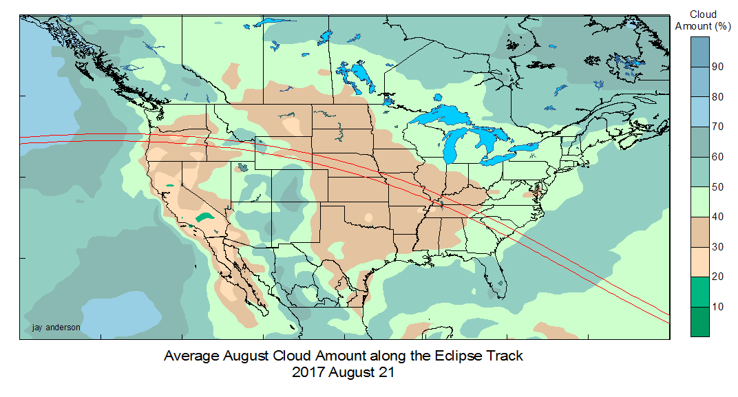
It is actually the worst weather spot along the entire track across the US as far as cloud cover goes. And it is off the center of the path so you only get 1 minute 17 seconds of totality.

But as the third highest point in the Appalachian Mountains you will be able to see for miles, so you will be able to see the shadow of the eclipse spot rushing up to you as totality begins, and see the shadow rushing away from you after totality ends. That is something that eclipse watchers on level ground won't be able to see.
farmerman
 
  1  
Reply Thu 8 Sep, 2016 02:04 pm
@oralloy,
I like the area at Klingmans or Mt Mitchell . Ive been up-toppity Mt Mitchell and have been above the clouds.(there with all the friendly skunks)
farmerman
 
  1  
Reply Thu 8 Sep, 2016 02:16 pm
@farmerman,
ahhh forget it. Mitchell is out of the totlity lne. So its Clingmans. That place will be a zoo, as will Casper Wyo.

maybe a street view from Nashville. Take some weird shots of the street during totality
ehBeth
 
  1  
Reply Thu 8 Sep, 2016 02:28 pm
@ehBeth,
ehBeth wrote:
(I'm going to take another look at my FB friends list - I think I have some dance friends in that area that I may try to hit up for some floor/sofa space)


looks like a space just outside St. Louis may be happening for me

(crossing fingers and toes)
0 Replies
 
oralloy
 
  1  
Reply Fri 9 Sep, 2016 08:17 pm
@farmerman,
farmerman wrote:
So its Clingmans. That place will be a zoo,

One of the sites mentioned mountaintops near Jackson Hole Wyoming as another place where people could look down and see the moon's shadow moving across the landscape. But with the high altitude comes a risk of bad weather compared to the valleys.


farmerman wrote:
will be a zoo, as will Casper Wyo.
maybe a street view from Nashville. Take some weird shots of the street during totality

Nashville has yucky odds of clear skies compared to sites further west. I'd hesitate to go east of Carbondale.

I'm thinking either Casper or St. Joseph/Kansas City.

My heart is telling me to aim for Casper (two day drive from Michigan, each way).

My brain is telling me to aim for Saint Joseph (one day drive from Michigan each way).
0 Replies
 
oralloy
 
  1  
Reply Mon 12 Sep, 2016 04:25 am
http://wyoparks.state.wy.us/images/SolarEclipse/Wyoclipse%20logo.jpg
Quote:
Really want to see the eclipse but worried you’ll have clouds above you?

We have you covered. In the near future you can purchase a State Parks day use pass for August 21, 2017 and view the eclipse from any of the State Parks within the path of totality.


Can I reserve camping now?

Stay tuned… You’ll soon be able to reserve an eclipse package at those parks under the path of totality. This package will include your campsite, eclipse viewing glasses, and some items that will let folks know where you were during this tremendous event. We are currently working with our Reservation System to get new sites added and ready! Be sure to not miss it by keeping an eye on our website for the 2017 Solar Eclipse!

http://wyoparks.state.wy.us/Press/SolarEclipse.aspx
farmerman
 
  1  
Reply Mon 12 Sep, 2016 11:14 am
@oralloy,
all I need is a Walmart store locator map. My RV needs nothing but a "Car" to tow her by.
ehBeth
 
  1  
Reply Wed 28 Jun, 2017 06:40 pm
US tourism plans cancelled for us.

Occom Bill is planning a biggish viewing get-together. Found a property in the path of maximum viewing that can be used for camping.
oralloy
 
  1  
Reply Wed 28 Jun, 2017 06:49 pm
@ehBeth,
ehBeth wrote:
Occom Bill is planning a biggish viewing get-together. Found a property in the path of maximum viewing that can be used for camping.

In a state with favorable cloud cover?
0 Replies
 
oralloy
 
  0  
Reply Mon 24 Jul, 2017 10:30 am

For those of us headed to Wyoming:

http://eclipsecasper.com

http://www.windrivereclipse.org

http://www.eclipsecelebration.com
farmerman
 
  1  
Reply Mon 24 Jul, 2017 12:12 pm
@rosborne979,
I JUT NOTICED on your map, Knoxville nd Nshville are reversed
Region Philbis
 
  1  
Reply Mon 24 Jul, 2017 12:22 pm
@farmerman,

it's possible they just slid the text over so it wouldn't be on top the "Longest duration" note...
farmerman
 
  1  
Reply Mon 24 Jul, 2017 12:35 pm
@Region Philbis,
in that case they could have easily reversed the two city names. same no. of letters.Im talking about ros very first map with the town names on the P.T.
 

Related Topics

New Propulsion, the "EM Drive" - Question by TomTomBinks
The Science Thread - Discussion by Wilso
Why do people deny evolution? - Question by JimmyJ
Are we alone in the universe? - Discussion by Jpsy
Fake Science Journals - Discussion by rosborne979
Controvertial "Proof" of Multiverse! - Discussion by littlek
 
Copyright © 2024 MadLab, LLC :: Terms of Service :: Privacy Policy :: Page generated in 0.04 seconds on 04/24/2024 at 08:09:16